| Authors: | Alejandro Valdecantos (CEAM),V. Ramón Vallejo (UB), Susana Bautista (UA), Matthijs Boeschoten (UU), Michalakis Christoforou (CUT), Ioannis N. Daliakopoulos (TUC), Oscar González-Pelayo (UAVR), Lorena Guixot (UA), J. Jacob Keizer (UAVR), Ioanna Panagea (TUC), Gianni Quaranta (UNIBAS), Rosana Salvia (UNIBAS), Víctor Santana (UAVR), Dimitris Tsaltas (CUT), Ioannis K. Tsanis (TUC) |
| Editor: | Jane Brandt |
| Source document: | Valdecantos, A. et al. (2016) Report on the restoration potential for preventing and reversing regime shifts. CASCADE Project Deliverable 5.2 104 pp |
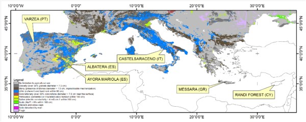
Within the six CASCADE field sites (Figure 1), there is a clear climatic gradient (Table 1). Two of the sites fall within the humid climate, three belong to the dry sub-humid climate, and one is classified as semi-arid. The average annual rainfall ranges from 267 mm yr-1 in Albatera to 1289 mm yr-1 in Castelsaraceno. There are also large differences in temperatures along the field sites. Castelsaraceno is again the coldest station with average annual mean temperature below 10ºC, while the hottest field site is Randi forest in Cyprus with mean annual temperatures close to 20ºC. The two Spanish sites show the lowest aridity indices (0.16 and 0.26 in Albatera and Ayora, respectively) while Castelsaraceno and, in a lesser extent, Várzea showed the highest aridity indices (1.05 and 0.84, respectively). Therefore, in addition to types and levels of degradation pressures, the CASCADE project includes a great variety of climates, soils, land uses and land use history (Table 2) that may eventually condition the loss of ecosystem services as described in Daliakopoulos and Tsanis (2013).
Table 1: Climatic characteristics of the six CASCADE field sites
| Várzea | Albatera | Ayora | Castelsaraceno | Messara | Randi | |
| Climate | Humid | Semi-arid | Dry sub-humid | Humid | Dry sub-humid | Dry sub-humid |
| Average annual rainfall (mm) | 1170 | 267 | 385 | 1289 | 503 | 489 |
| Average mean temperature (ºC) | 13.0 | 18.0 | 14.6 | 9.1 | 17.9 | 19.5 |
| Aridity Index (mm/mm) | 0.84 | 0.16 | 0.26 | 1.05 | 0.31 | 0.29 |
| PET (monthly) | 118.6 | 136.0 | 123.4 | 102.5 | 136.0 | 141.5 |
Table 2: Summary of main properties of the six CASCADE field sites
| Varzea | Albatera | Ayora | Castelsaraceno | Messara | Randi | |
| Elevation | 450-600 m | 225-310 m | 830-1030 m | 972-1284 m | 100-230 m | 90-230 m |
| Bedrock | Schists | Dolomites, conglomerates and sandstones | Marl and limestone colluvium, limestones | Limestones and dolomites | Limestones and marls | Marls |
| Soils | Cambisols | Calcisols, Cambisols and Fluvisols | Regosols, Cambisols and Leptosols | Regosols | Cambisols and Luvisols | Calcaric regosols |
| Land use | Forests and shrublands (and agriculture in lesser extent) | Agriculture (52%) and shrublands (24%) | Forests and shrublands | Cropland, pasturelands and forests | Croplands and shrublands | Croplands and shrublands |
| History | Recurrent fires (1978, 1985, 2005, 2012) | Abandonment of rainfed croplands, alpha grass harvesting and wood gathering, afforestations | Fire (1979) and abandonment of wood harvesting | Land abandonment (especially after 1990s) | Overgrazing and overexploitation of water resources | Agriculture and grazing |
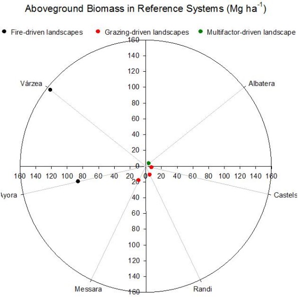
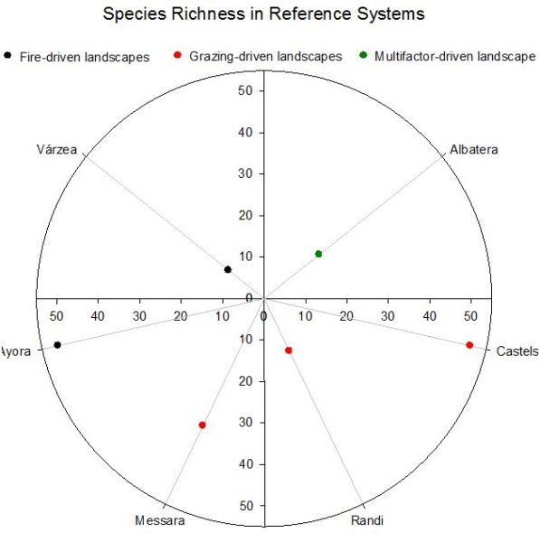
Similarly, the ecosystems that have been selected as references or undisturbed states of the ecosystem also show much contrasted values of key ecosystem structure and function properties (Figures 2 and 3).
Fire-Driven Landscapes
The two field sites affected by wildfires share the mature forests of maritime pine (Pinus pinaster) as the Reference state of the ecosystem. But the assessment of losses of ecosystem properties and services due to degradation has been conducted at two contrasted time scales: at the very short term on a repeatedly burned site (Várzea) and at the long term on a community without significant recovery of the overstory layer (Ayora). The restoration potential has also been assessed through rather different approaches: by actions carried out within the first year (Várzea) or 23 years after the fire (Ayora).
Várzea
The reference state in Várzea is represented by a forest of maritime pine (Pinus pinaster) where no wildfire has occurred since 1975. At the opposite extreme, the degraded areas suffered four wildfires occurred since 1975, the last one in 2012. A third situation was represented by areas that burned twice (1985 and 2012) and where burned trees were removed after the last fire by two contrasting methods: standard or traditional logging in which all wood was removed from the site, and conservation logging, in which logging residues were left on the ground organized in piles. Both logging activities were conducted during the first year after the fire and implied the cutting of all burned trees.
The experimental setup was conditioned by land availability of the burned area. Three spatially replicated plots of ca. 1000 m² were established in the reference mature pine forest (> 40 years old), in the 4-times burned (last fire in 2012) and in the standard logging areas, while three smaller plots were selected under the conservation logging treatment.
As the number of blocks was different in the reference and conservation logging sites (3) in relation to the degraded and traditional logging sites (1), we randonmly selected transects (plant cover and LFA – Landscape Function Analysis) and subplots for biomass assessment (aboveground and litter; see »Measurement of ecosystem properties and the potential for their restoration) to balance the data. In the case of the conservation logging, plots were differentiated by piles (accumulation of woody residues), inter-piles (lines between piles) and roads (paths or tracks for logging machinery). Sampling was proportionally conducted on these three contrasted spatial situations.
- The composition of the plant community of areas subjected to Traditional and, especially, Conservation logging is closer to the Reference than the Degraded areas
- The disposal of plant remains on the soil surface after wood removal increased the cover and size of patches and, hence, the conservation of resources
- However, plant remains on soil might hamper the recruitment of some species, especially seeders, with direct consequences of diversity indexes and biomass build up
- Ecosystem functioning assessed as LFA’s stability, infiltration and nutrient cycling indexes were improved by the restoration approaches but are still far from the natural forest
- In general, restoration actions improved ecosystem properties and services at the very short term after their implementation although the dynamics of the plant communities were slowdown, probably due to the impact of the heavy machinery on the earliest regenerated plants
For more details see »Várzea Portugal: Restoration potential for preventing and reversing regime shifts
Ayora
The Reference ecosystem is a mature pine forest of Pinus pinaster and P. halepensis that was traditionally managed for different uses. The degraded ecosystem is an old and dense shrubland where pines did not recover after a wildfire in 1979. This >30 years shrubland bears a very high risk of fire as it accumulates large amounts of standing and ground fine, dead fuel. In 2003, restoration actions were carried out with the main objective of reducing fire risk. These actions included selective clearing of fire-prone shrub species and planting seedlings of more resilient resprouter species.
Three spatially replicated plots were established under three states of the ecosystem and followed the evaluation protocol used in all sites.
- The degraded state represents an ‘old’ shrubland where gorse disappeared by natural senescence and was dominated by rosemary
- The bigger size of patches in the restored areas can be related to the collapse of old shrubs in the degraded plots resulting in openings in the continuous shrubland
- Biodiversity was the most improved service by restoration actions
- But also the restoration approach considered in Ayora, with the reduction of levels of understory biomass, improves the ecosystem service ‘fire risk reduction’ even ten years after the application of treatments
For more details see »Ayora, Spain: Restoration potential for preventing and reversing regime shifts
Grazing Driven Landscapes
Grazing is the major degradation pressure in three out of six CASCADE field sites. From those, Messara and Randi share many landscape characteristics, physical features and land use histories while Castelsaraceno shows clear specificities. The three sites represent a good example of the most important environmental and socio-economic features of their respective regions.
Castelsaraceno
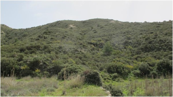
The vegetation cover for the study site shows that broad-leaved forest is the most representative land cover and only a small part of the land is devoted to agriculture. After 2000, and due to rural exodus, a large part of the territory is covered by natural grassland and broad-leaved forest. Land cover under transition is noteworthy and there has been progressive woods and shrublands encroachment on former pastures. The target Reference ecosystem is a productive pastureland with a sustainable grazing pressure composed by annuals and, in a lesser extent, perennial grasses, and where shrubs disappeared because livestock farming is widespread. Since 1991, the land has been unevenly grazed resulting in over- and undergrazed zones depending on the stocking rate supported.
Two different restoration approaches have been considered in Castelsaraceno in relation to the different grazing pressures. For the undergrazed situation, where shrubs were colonizing, the restoration action was a selective clearing of vegetation 10 years before the ecosystem assessment was made. When overgrazing was the degradation driver, fencing (8-15 years before the assessment) to avoid animals was the restoration measure considered.
The experimental setup in Castelsaraceno included three spatially replicated blocks, Monte Alpi, Favino and Piano del Campi. We have identified Reference, Overgrazed, Undergrazed, Fenced and Cleared ecosystems in all of them and three replicated plots were established for each block x pressure combination (15 plots).
- Different restoration approaches were considered depending on the sense of the grazing pressure: Fencing in case of overgrazing, and clearing woody vegetation in case of undergrazing.
- The degradation due to overgrazing seems more pronounced than that due to undergrazing. The losses of services provided in relation to the reference productive grasslands in the overgrazed are higher than in the undergrazed.
- Ten years after the application of restoration, the ecosystem services evaluated in this study have been slightly improved.
- Biodiversity is the most improved service associated to the two restoration approaches.
- In the areas affected by overgrazing, restoration did not achieve the overall balance of services provided by the references while in the undergrazed areas the restoration through clearing showed the highest balance of services.
- Provisioning services associated to grazing should be specifically considered in Castelsaraceno and integrate them into the final analysis.
For more details see »Castelsaraceno, Italy: Restoration potential for preventing and reversing regime shifts
Messara
The natural landscape in Messara is dominated by the evergreen maquis/phrygana and the main driver of pressure to these reference ecosystems is grazing. Many marginal areas under natural vegetation were cleared in the past and planted with olives. Widespread olive production in steep hilly areas in combination with grazing has triggered desertification processes. In addition, further land abandonment led to less productive lands susceptible to degradation and at the same time grazing pressure significantly increased (more than 200% increases in sheep and goats between 1980 and 1990).
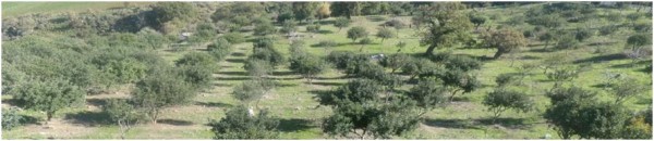
In addition to the Reference and Degraded ecosystems, we selected an intermediate state of pressure defined as Semi-Degraded. It was difficult to find areas subjected to any restoration action in the past in Messara. However, we found two areas where carob trees orchards were established on overgrazed areas: Melidochori and Odigitria. In Melidochori (Figure 4), restoration works started in 1998 and two years old carob tree (Ceratonia siliqua) seedlings were planted in 2000 in a 6 x 6 m grid with maintenance actions (irrigation, fertilization and replanting dead individuals) for the first three years after planting. Grazing was excluded for ten years. LFA assessment was conducted 14 years after the establishment of the actions. Carob trees in Odigitria (Figure 5) were established by the homonymous monastery about 7 years before the assessment and irrigation was conducted during the first two years after planting. No other maintenance actions were considered. In contrast to the Melidochori site, grazing is not controlled in Odigitria.
Three replicated plots were established in the Reference, Degraded and Semi-Degraded states but one of the Semi-Degraded plots was completely affected by a fire in summer 2013 before the field assessment and only two plots were left. Only one plot was established in the two Restored areas.
- The lack of areas with similar biophysical properties and land use histories that underwent any kind of restoration action in the past impeded to fully apply the ecosystem service protocol
- The two restoration plots found included the transformation of overgrazed areas to carob tree orchards
- Contrary to expected, interpatch cover and size were enhanced in the restored areas but the cover of bare soil was reduced as compared to the overgrazed degraded areas
- The Melidochori approach significantly improved the infiltration index from the degraded lands while the Odigitria restoration enhanced the nutrient cycling
- Plant cover, diversity and biomass data are needed to fully calculate regulating ecosystem services.
For more details see »Messara, Grete: Restoration potential for preventing and reversing regime shifts
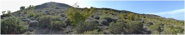
Randi Forest
The natural landscape is the result of human activities and is dominated by shrublands, the typical Mediterranean phrygana, with open areas with shrubs and sparse carob and olive trees. The three studied states of the ecosystem in Randi, Degraded, Reference and Restored areas, used to be pine forest 100 years ago. After the allowance to local people to cut the pine forest and use them for firewood, only shrubs and olive trees were grown in the area but the land is not suitable for agriculture anymore and it is used for grazing, in particular goats and sheep. In the decade of 1950 goat and sheep farms were established in the area and started grazing the areas around the farms. The Restored areas (Figure 6) are far from the farms but were grazed at different intensities depending on the distance to the shelters. Animals were excluded 20 years ago from these areas but continued to graze in the degraded and on the borders of the restored areas.
Three replicated plots were established in the Restored areas and the assessment protocol used in all sites was completely and strictly applied in all of them.
- Restoration by long-term grazing exclusion increased plant cover, litter accumulation and aboveground biomass to similar levels found in the undisturbed reference areas
- Plant composition and spatial structure of vegetation (cover and size of patches and interpatches) also reflected differences in the three ecosystem states
- Ecosystem functioning, mainly nutrient cycling and infiltration, is sharply improved in the restored areas but are still far to the values observed in the references
- The five ecosystem services calculated did not show differences between the Restored and the Reference areas and were significantly improved form the Degraded lands
- Restoration in Randi can be considered as successful with the approach followed in the project
For more details see: »Randi Forest, Cyprus: Restoration potential for preventing and reversing regime shifts
Multifactor Driven Landscapes
Albatera
In this site, degradation of natural shrubland areas has resulted from a complex interplay of multiple drivers (some of them are no longer active), especially past over-exploitation of resources (overgrazing, mining, multiple cycles of marginal agriculture and land abandonment, and fire-wood gathering), in combination with harsh climate conditions. However, there are some scattered healthy shrubland areas that have been subjected to low past pressures and remain in a reasonably good shape. These areas represent the Reference state of the ecosystem. This site holds two different scenarios for the assessment of restoration actions, differing in both the implementation time and in the technologies and species used:
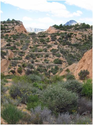
- Old (traditional) Restoration. Implemented over the 1970s and 1980s, and consisting on a plantation of only one tree species, Pinus halepensis (Aleppo pine), on large afforestation bench terraces (Figure 7). A number of pine forest patches scattered on terraced slopes with varying degradation degree have resulted from this action.
- New (ecotechnological) Restoration. In 2003 – 2004, a demonstration restoration project was performed by the Regional Forest Administration on one small catchment (24 ha) in the Albatera range area. The project counted on the scientific advice of CEAM and the Department of Ecology of the University of Alicante and it was designed to specifically combat degradation of drylands. The restoration action was performed combining several field techniques and plant species through spatially heterogeneous plantations, to better address the characteristic high heterogeneity of dryland landscapes (Chirino et al., 2009; Figure 8).
Three replicated plots were established in the two alternative restoration approaches and the common assessment protocol was completely applied in all them except litter accumulation and root biomass.
- Old restoration especially affected the contributions of sink and source areas to the landscape and their morphology
- New restoration especially affected biodiversity and vegetation structure and biomass
- The extremely harsh conditions in Albatera determine low recovery rates of ecosystem structure and function after restoration
- New restoration improved ecosystem services in higher extent than old restoration in Albatera
- At the medium and long term after restoration, ecosystem services are still far from those provided by natural undisturbed ecosystems
For more details see »Albatera, Spain: Restoration potential for preventing and reversing regime shifts
Note: For full references to papers quoted in this article see