| Contributing Authors: | Matteo Jucker Riva, Gudrun Schwilch, Hanspeter Liniger |
| Editor: | Jane Brandt |
| Source document: | Jucker Riva, M., Schwilch,G., Liniger, H. 2016. A method for resilience assessment. CASCADE Project Deliverable 7.2, 61 pp |
1. Identification of the assessed land management systems
General information on the land management systems assessed was collected through the first part of the RAT. In particular, the name of the land management system (Table 1, column 3) had to reflect the environment, but also the main objective of land management.
Table 1: Identification of the land management systems analyzed with the Resilience Assessment Tool.
Variables considered are 11a, 11b, 11d, 11e, 13a, 121a (see »Resilience Assessment Tool)
| Study Site Name | Country | Name of the Land Management System | Unique Code | Main Author and Affiliation |
| Várzea | Portugal | Recently burnt maritime pine plantation subjected to logging, with withdrawing of forest slash residues and conditioning machinery movement to minimize impacts on pine recruitment | Por_1 | Keizer Jan Jacob, University of Aveiro (Portugal) |
| Várzea | Portugal | Recently burnt maritime pine plantation subjected to traditional logging following the fire, with extraction of all the woody material and use of heavy machinery | Por_2 | Keizer Jan Jacob, University of Aveiro (Portugal) |
| Ayora | Spain | Pinus halepensis afforestation managed with selective clearing and firebreaks for landscape conservation and controlling soil erosion | Spa_2 | Baeza Jaime, CEAM Foundation (Spain) |
| Ayora | Spain | Shrubland under selective clearing and planting for fire risk reduction and resilience increase | Spa_3 | Baeza Jaime, CEAM Foundation (Spain) |
| Messara | Greece | Carob afforestation on grazing land for land restoration and income diversification | Gre_1 | Panagea Ioanna, Technical University of Crete (Greece) |
| Randi | Cyprus | Extensive grazing system with carob and tree protection and fodder provision | Cyp_1 | Christoforou Michalakis, Cyprus University of Technology (Cyprus) |
| Castel Saraceno | Italy | Seasonal high altitude cow pastures managed with metallic fences to regulate grazing | Ita_1 | Quaranta Giovanni, University of Basilicata (Italy) |
| Albatera | Spain | Spatially diverse multi-specific plantation to restore degraded shrubland and combat desertification | Spa_1 | Bautista Aguilar Susana, University of Alicante (Spain) |
Table 1 shows the list of land management systems assessed using the RAT. The first four land management systems are located in forest areas where the main driver of land degradation is fire. The land management systems located in Greece and Cyprus are similar in terms of land use (animal farming) which is also the main pressure driver. Also the Italian study site's main land use is grazing, but overgrazing is not a problem there, as the climate is much more humid than in Greece and Cyprus (see Table 2). The last site is Albatera, where the degradation is mostly due to previous agricultural use of the land. The study sites will be presented throughout this section of CASCADiS in the same order used for Table 1, in order to facilitate comparison. The most relevant question answered in Table 1 is: "What is the name of the land management system?" (variable 13a, see »Resilience Assessment Tool)
2. Description of the system
Table 2 shows the information, collected through the RAT that characterizes the natural and human environment of the land management system. The categories and definitions used are coherent with the WOCAT indicators and are derived from questions in section 5 of the RAT. The main questions are: “5.1.2 Agro-climatic zone”,”5.1.3 Landforms”,”5.1.4. Which land use type constitutes the land management system?”, ”5.1.5. Previous land use type(s) in the last 100 years”, “5.1.7. Who is managing the land management system?”(see »Resilience Assessment Tool).
Table 2: Description of the natural and human environment of the land management systems analyzed with the Resilience Assessment Tool.
Variables used are: 11e,121b, 512a,513a,514a,514b,514c,515a,515c,515d,517a, 517b,517c,517d (see »Resilience Assessment Tool)
| Unique Code | Climate | Land forms | Present land use(s) | Past land uses (date of change in years from present) |
Land managers |
| Por_1 | sub humid | Hill slopes | Fp: Plantations | Ge: Extensive grazing land; (50) | Employee, small scale land users Leaders / privileged Mainly men |
| Por_2 | sub humid | Hill slopes | Fp: Plantations | Ge: Extensive grazing land; (50) | Employee, Small scale land users Leaders / privileged, Mainly men |
| Spa_2 | sub humid | Plateau/plains, Mountain slopes, Valley floors |
Fo: Other; Fn: Natural forests; Fp: Plantations |
Ma: Agro-silvopastoralism; (60) Mf: Agroforestry |
Employee, Small scale land users Mainly men |
| Spa_3 | sub humid | Plateau/plains Valley floors |
Fo: Other; Fp: Plantations |
Ca: Annual cropping; (60) Fn: Natural forests; Ca: Annual cropping |
Employee |
| Gre_1 | sub humid | Hill slopes | Fp: Plantations Ms: Silvo-pastoralism |
Gi: Intensive grazing/ fodder production; (15) Mp: Agro-pastoralism; |
Individual/household, Leaders/privileged Mainly men |
| Cyp_1 | semi-arid | Plateau/plains, Hill slopes |
Ge: Extensive grazing land; Gi: Intensive grazing/ fodder production; |
Ct: Tree and shrub cropping; (20) Gi: Intensive grazing/ fodder production; |
Individual/household, Small scale land users, Common/average land users, Mainly men |
| Ita_1 | sub humid | Mountain slopes | Ms: Silvo-pastoralism | Ca: Annual cropping; (50) Ms: Silvo-pastoralism; |
Individual/household, Medium scale land users, Mainly men |
| Spa_1 | semi-arid | Ridges, Mountain slopes, Hill slopes |
Fp: Plantations; Fn: Natural forests; |
Ge: Extensive grazing land; (Unknown) Ct: Tree and shrub cropping; |
Employee, Mainly men |
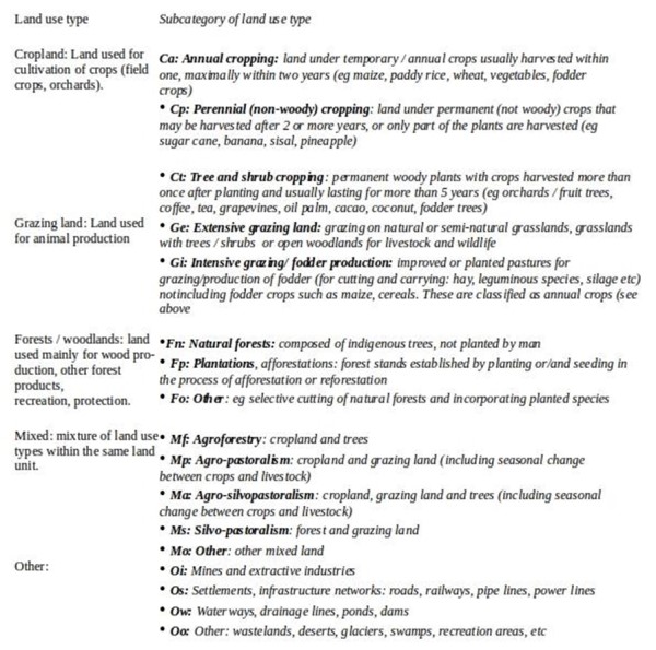
The land use in the study site has been categorized adopting the WOCAT classification as shown in Figure 1.
Details about climate together with trends and past changes have been presented in detail in »Study sites, (particularly the articles entitled "Description of site and main causes of degradation"). To that we can add an observation from the RAT implementation: in the last 2 years, climatic extremes have characterized the majority of the study areas; the driest ones (Randi, Albatera and Ayora) have experienced droughts, while Castelsaraceno and Várzea have experienced higher rainfall than normal.
The CASCADE project studies natural and semi-natural ecosystems; it comes as no surprise that most of the land management systems analyzed are located outside the plains, in hilly or mountainous areas (Table 2, column 3). From the categorization of present land uses we can immediately identify a difference between forest systems and grazing systems: the former (Por_1, Por_2. Spa_2, Spa_3) are rather homogeneous; the latter, despite having a clearly dominant land use, are more heterogeneous. During meetings, the farmers interviewed have repeatedly stressed the importance of having multiple land uses and vegetation types to increase quality of fodder and reduce production failure risks: this is particularly important in drier areas (Gre_1 and Cyp_1) where one single land use/vegetation type cannot support the animal farming all year round. The 5th column of Table 2 shows that all the land management systems analyzed have had a major land use change in the last 60 years. This is consistent with the general pattern of the Mediterranean countryside: during the industrial boom of the 1950s and 60s there has been a massive change in the way natural and semi-natural ecosystems were used, the old localized and self-sufficient land use mosaic changed towards a more industrialized and homogeneous land use (Cyp_1, Por_1, Por_2) or towards land abandonment when the land was not productive enough anymore or the attraction of nearby cities was higher.
Most land management systems analyzed fall in the second category. This is particularly important for the system Ita_1, where a change in the economic system completely changed the dominant land use, almost abandoning the farming practices in the area and caused what could be identified as a regime shift in the environment.
Moreover, the impacts of past land uses is not only still visible today, but has direct implication on the resilience of the environment to disturbances and on the effectiveness of land management practices. (c.f.. A prominent example is Spa_1, where the terraces created during the agricultural exploitation of the area influence the infiltration capacity of the soil, and thus the ability of the natural vegetation to colonize the area. Also in the forest areas of Ayora (Spa_2) the agricultural activities of more than 50 years ago still have an impact on the type of vegetation, on its flammability and ability to recover after a fire.
The management is mainly performed by private companies or government agencies in forest and natural areas (Portugal and Spain), while individuals are in charge of land management in grazing areas.
Table 3 shows the most important land management practices implemented in each land management system. Among them there are practices that are considered particularly promising by land managers or researchers in increasing the resilience of the land management system (Por_2, Spa_1, Spa_3, and Gre_1). Others can be considered "traditional" or of wide-spread use (Por_2, Ita_1, Spa_2, and Cyp_1). A more complete description of each land management practice is provided in »Resilience Assessment Tool.
Table 3: Land management practices in the study sites and relation with the WOCAT database.
Variables considered are 131a-131f (see »Resilience Assessment Tool)
Note: For full references to papers quoted in this article see