| Authors: | Quaranta, G. and Salvia, R. |
| Coordinating authors: | Tsanis, I. K. and Daliakopoulos, I. N. |
| Editor: | Jane Brandt |
| Source document: | Daliakopoulos, I. and Tsanis, I. (eds) 2014. Historical evolution of dryland ecosystems. CASCADE Project Deliverable 2.1. CASCADE Report 04. 126 pp. |
Description of the study site
General information
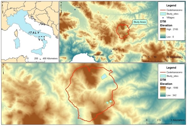
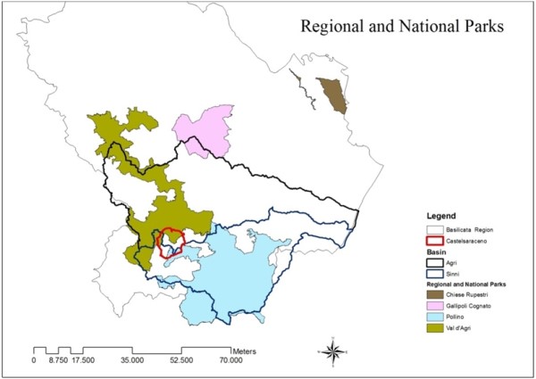
The Castelsaraceno Study Site is situated in the south-west of the Basilicata region of Southern Italy. Castelsaraceno has a surface area of 74.3 km² and a population of 1,507 with a density of 20.28 inhabitants per km² (less than on third of the Basilicata Region). The study site straddles two national parks, the National Park of Pollino and the Lucano Apennine Val d’Agri Lagonegrese National Park, a vast protected area of Basilicata region including the Agri River and some of the highest peaks of the Lucano Apennines.
Castelsaraceno is representative of the most important environmental and socio-economic features of Basilicata region, which has particular climatic conditions that are influenced by its orographic nature and proximity to the Tyrrhenian and Ionian seas. There is a typical Mediterranean climate along the Ionian coast up to 500 – 600 m, characterised by scarce rainfall concentrated during the autumn-winter period and by summer drought. Above these altitudes and up to 2000 m the climate is temperate-cold with mild dry summers. At higher zones, and towards the Tyrrhenian Sea, the climate is cold and rainy. The geomorphology of the region reflects its geological and lithological nature, with both volcanic and calcareous mountains and plains made up of gravel, sand, clay and flysch, alluvial plains, fluvial terraces and alluvial cones with abundant gravel and clay-silt deposits, undergoing erosion. These calanchi (badlands) are a type of terrain with clay-rich soil, typical of the Basilicata region, characterizing most of its internal hilly areas. The complex alternating situations and economic and environmental importance of this region make it ideal for an analysis of the components affecting the different stages of environmental sensibility.
Topography
Castelsaraceno stands at 916 m but ranges from 675 m (Acqua di San Giovanni) to 1,861 m (summit of Mount Alpi). The area is bordered to the north by Mount Raparo (1,764 m), which offers protection from northerly winds, to the south by Mount Alpi, Mount Armizzone and Armizzoncello, to the west by Pietra Marina Castelveglio, to the north-east by a wide valley and to the east by a horizontal line of mountain ranges which includes the peaks of Tuppetto and Mount Asprella.
The territory of Castelsaraceno covers two hydro-geological basins, the larger Agri river basin and the smaller Sinni river basin. The Sinni river basin has predominantly mountainous and hilly morphological characteristics. The highest peaks in the territory are situated along the western and south-western border of the basin, one of which is Mount Alpi (1,892 m) and part of the Castelsaraceno territory is made up of an area with Mesozoic mountain series made of: siliceous limestone strata with intercalations of marl and clay with varying thickness; alternations of polychrome and radiolariti siliceous argillaceous rocks in thin strata; silciferous and siliceous argillaceous stone. The area is also characterised by severe erosion and diffuse landslides. As for hydro-geological characteristics of the territory, this part of the basin is characterised by a calcareous system and a dolomitic system with high permeability, which explains the presence of large aquifers.
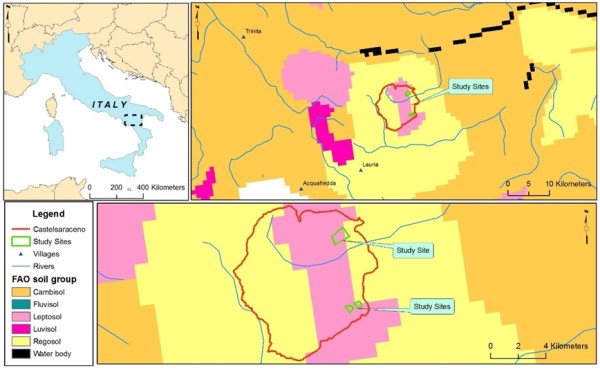
Geology and soils
The municipality of Castelsaraceno is situated in the Apennine mountain chain whose tectonic units derive from the complete inversion of basins, separated by platforms, formed following the tectonic extension of the middle and late Triassic period. The paleo-geographic domains have originated from Mesozoic tectonic units that constitute the Apennine Chain (tectonic units that are overlapping from Miocene epoch). From West to East stands the Liguride unit formation, resulting from the deformation of the Tethys oceanic domain, which stands above the Apennine platform. In turn, this unit lies tectonically above the sediments of the Lagonegrese basin, characterized by numerous folds and over thrusts. The Sicilide and Irpine units emerge more frequently in the front portion of the chain. The Sicilide Units mainly consist of shale and severely deformed marls, whilst the Irpine Units are characterized by silico-clastic sediments, which record the progressive deformation of the Apennine chain.
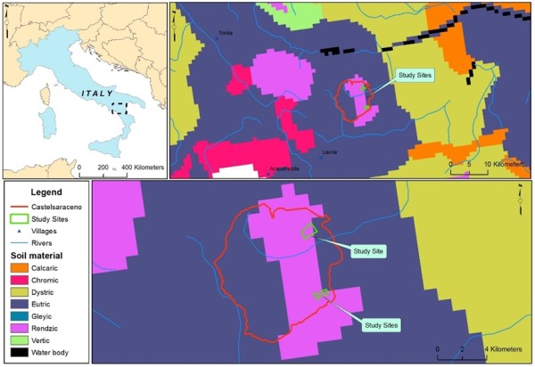
Castelsaraceno also lies within one of the most complex areas of the Southern Italy Apennines. In fact this area has the typical southern Italian Apennine alignments NW – SE and N – S with also the directions W – E and WNW – ESE which characterise the structures of the neighbouring Calabria region. The basin of the river Agri is also predominantly mountainous and includes Mount Raparo (1,764 m). It is characterised by limestone, dolomites, calcareous debris in strata and slabs–in places intensely fractured or with section formations of cataclastic rock. This area is also characterised by frequent landslides.
The carbonates formed between the late Triassic and the Tertiary (Neocene) periods in an area of the platform span between the Liguride domain and the Lagonegrese Basin. They separate the complex into three units, characterised by sequences of varying thickness and facies and are therefore found in different paleo-geographic positions within a large area characterised by carbonate sedimentation. Mount Alpi is a limestone massif situated in the South-West of the Lucano Apennines. The chain is made up of a large Mesozoic carbonate sequence, around 1,000 m in facies, on which stand two distinct Neocene cycles. The oldest formations are limestone, dolomitic limestone and well-stratified dolomites passing to calcilutites (cement rock) with intercalations of oolitic limestone in higher layers. This sequence from the middle Jurassic - Lower Cretaceous epoch forms the backbone of Mount Alpi.
The following soils are present in the Castelsaraceno area:
- in hilly and mountainous areas with Mesozoic and Tertiary limestone rocks chalky soils are found;
- in the Apennines and anti-Apennine reliefs with tertiary sedimentary rocks such as marl sandstone and clay flysch there are high mountain marly soils and soils from central reliefs with rugged morphology;
- on the surfaces of the Bradanica trench with Pliocene deposits (fluvial deposits) soils of sandy hills and conglomerate rocks of the Basin of St. Archangel are found together with soils from floodplains.
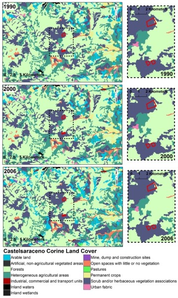
Land Use
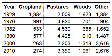
Most of the area is covered with broad-leaved forest. Only a small part of the surface is dedicated to agriculture and discontinuous urban fabric. Between the 1990s and 2000, land use remained more or less the same with the majority of the territory covered by broad-leaved forest and land principally used for agriculture with natural vegetation and an absence of non-irrigated arable land and sclerophyllus vegetation, mixed forest and bare rock.
After 2000, the area underwent substantial changes, to a large extent due to the significant reduction of population because of the continuing rural exodus affecting the area caused by lack of vital infrastructure and also in part due to the shift away from farming and towards occupations in other economic sectors. Land dedicated to traditional agricultural practices and self-sufficiency farming covers a limited area of Castelsaraceno and is concentrated in the area within the Park of Pollino and in the Sinni river basin; a large part of the territory is, instead, covered by natural grassland and broad-leaved forest. Land cover under transition is noteworthy and there has been a progressive encroachment of pastures towards woods and shrubland as well as variations in the use of Utilised Agricultural Area.
Climate
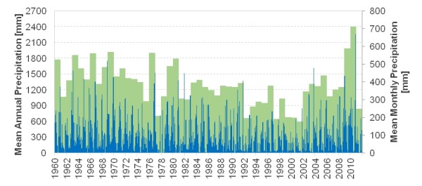
Castelsaraceno is characterised by a humid temperate climate with around 68% of rainfall occurring during winter months and 15% in summer months. There is a difference in annual precipitation levels between the Agri and Sinni river basins. The Agri basin receives between 900 mm and 1,700 mm a year although the eastern areas receive just 200 mm. The Sinni river basin and the south-west area receive between 900 mm and 1,300 mm a year whilst the NE areas receive just 200 mm. The municipality of Castelsaraceno itself has very high levels of rainfall, with an average at around 1,290 mm a year or about 108 mm/month. There has been a slight decline in monthly rainfall over time.
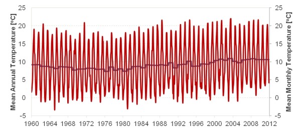
The average temperature in winter months is 4.2 °C with humidity at 76%, whilst summer months' average temperature is around 22 °C with humidity at 56%. Average annual temperatures in both basins are more or less stable at between 12 °C and 15 °C. The NW areas of the Agri basin have an average temperature of 16-17 °C as does the eastern areas of both basins. The Sinni basin, however, shows average temperatures of 12-15 °C in 80% of its territory. Over the available record, temperature shows a significant upward trend of about 0.5 °C per decade with an annual mean of 9 °C Nevertheless, it is possible that this trend is part of a larger oscillation and that the past two decades have been at the warm part of the cycle. The potential evaporation is estimated at 1,230 mm.
Hydrogeology
Castelsaraceno straddles two hydro-geographic basins, the Agri river basin and the Sinni river basin. Both basins are similar in terms of hydrology. In fact, both are characterised by significant numbers of springs, high precipitation levels and higher minimum and maximum flow rates than other basins in the region. In terms of stratification and structure, the calcareous-dolomite complex of both Mount Alpi and Mount Raparo are characterised by high permeability and so contribute to the size of the aquifers.
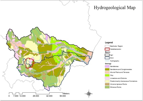
The Sinni basin receives water flow from Mount Alpi, whose springs (La Calda with average flow rate equal to 280 l/s and Caldanella with 18 l/s) provide Sinni with constant water flow. The water flow from Mount Raparo (with the spring Varco Laino with average flow rate of 154 l/s and Prastiolo with average flow rate of 55 l/s) feeds the river Agri.
In terms of hydrography and geology in the area there are:
- high permeable calcareous complexes with high fragmentation and dolomitic complexes with medium to high permeability based on the state of fragmentation (hydro-structure M. Raparo);
- clay-marl complex with low to zero permeability;
- sandy-conglomeratic complex with medium-high to medium-low permeability based on the thickness and cementation of deposits.
Water quality
In 1997 the Basilicata Region started a program to monitor surface water, ground water and sea water quality. The Agri and Sinni rivers have generally good quality of water, thanks also to the relatively low numbers of industries and large urbanised centres (most inhabited centres do not exceed 5,000 inhabitants). Principal stress factors are agricultural and tourism sector activities. The value of dissolved oxygen and BOD5, metal concentrates (Cd, Hg and Pb), total ammonia and non-ionized ammonia concentrations, values do not exceed limits set out in Dir. 98/83/EC.
Flora
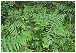
In the past agricultural areas were more extensive, but are now largely abandoned or used by wild animals for pasture. Nowadays, four distinct areas can be identified; Mediterranean macchia on the plains extending to 400 m; sub-mountainous oak and chestnut woodlands (400-1000 m); mountain beech and conifer woodlands (the latter in the Pollino area: 1000-2000 m) and, finally, alpine pasture. The hilly part of the region with vast pastureland includes chestnut groves, vineyards as well as olive groves on lower land. The flora in the study area significantly varies with open shrubland and grassland plains to termo xerophile and mesophile brush which have evolved in the area due to human induced impacts on the territory since ancient times (pasture and deforestation). Forest formations include (a) cerreta Malboschetto (forest of Cerris) and mixed plant communities of Turkey Oak and the Downy Oak degraded to differing degrees along the southern slopes of Mount Alpi and (b) Beech wood forests which stand at 1,200 to 1,750 m and cover the eastern, northern and western scope of the Alpi S.Croce formation.
Mountainous and hilly pastures are, instead, very diffuse and principally include:
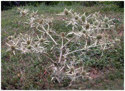
- Arid pastures with predominance of Eryngium campestre, Cynosurus cristatus, Ononis spinosa, Lolium perenne, Trifolium repens, (Pleum hirsutum, Cichorium intybus, Brachypodium pinnatum, Cirsium vulgare and, sporadically, Spartium junceum, Chrisanthemum leucanthemum, Inula viscosa), Dorycnium pentaphyllum. The pastures are found between 1,000 and 1,400m and are relatively evenly distributed over the territory and have the physiognomic characteristic of Cynosurus cristatus. Pastures with clearings between watersheds occupied by beech forests and the summit area are physiognomically dominated by Festuca circummediterranea and Bromus erectus.
- Open steppa populations, on eroded soils to a greater or lesser degree, with Spartium junceum, Calamintha nepeta, Teucrium polium, Teucrium chamaedrys, Bromus erectus, Sideritis syriaca, Helicrysum italicum, Scabiosa crenata and Stipa austroitalica to name just the most important species. In the locality of Pietra Longa and Tempa Carlone these groupings are dominated by large populations of Quercus ilex rupicoli.
- Sodaglie (fallow and untilled soils) to Pteridium aquilinum, in which Carlina acaulis, Digitalis ferruginea, Centaurium erythraea are found.
Largely diffuse are also:
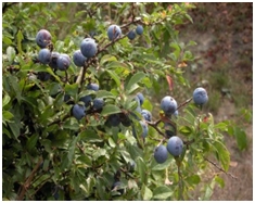
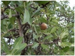
- Thermo-xerophilous bushes, linked to stages of degradation (or evolution) of Sesille Oak forests. In addition to Quercus pubescens, the bushy layer is essentially made up of Prunus spinosa, Crateagus monogyna, Pyrus amygdaliformis, Spartium junceum and Alnus cordata. In the less arid areas: Ulmus minor with infiltrations of Quercus cerris and Fagus sylvatica.
- Thermophile woods with prevalently Quercus pubescens and Alnus cordata, with Carpinus orientalis and Pyrus amygdaliformis, sometimes with conifers.
- Mesophyll woods Alnus cordata and Fagus sylvatica, with Quercus cerris, Acer pseudo-platanus, Acer campestre, and underwood with meadows and areas of woodland plants (nemorali).
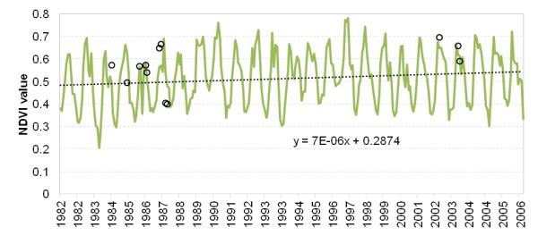
Some areas, such as Mount Teduro and Tempa Carlone, have been reforested, almost exclusively with Pino Nero (Black Pine) species, which often did not produce the anticipated results and even after many years have generally produced extremely impoverished forest populations. A synoptic view of the vegetation health and the associated function of ecosystems reveals a slight upward trend since the 1980s.
Fauna
The territory of Castelsaraceno has a large variety of fauna, as it is located between two large protected areas (the National Parks of Pollino and Val d’Agri-Lagonegrese). All principal species of mammals found in the southern Apennines are present in the local territory. Carnivores present include a discreet population of wolves (Canis lupus), wild cats (Felis silvestris) and others, which are found in the various water courses with good vegetation cover along the river banks. Rivers and humid environments represent an ideal habitat for various species of some migratory birds such as Black Storks (Ciconia nigra) and White Storks (Ciconia ciconia). Higher altitudes, above 1,500 m, are home to larger predatory birds such as the Golden Eagle (Aquila chrysaetos), the Peregrine Falcon (Falco peregrinus) and the Common Raven (Corvus corax). At slightly lower altitudes in the oldest forest areas the Great Eagle Owl (Bubo bubo) can be seen, whilst hilly areas are particularly inhabited with Red Kites (Milvus milvus) and the common Buzzard (Buteo buteo). In more humid areas, the Black Kite (Milvus migrans) and the Western March Harrier (Circus aeruginosus) can be seen. Other significant population includes wild boar (Sus scrofa) and roe deer (Capreolus capreolus). Finally, aside the common European hare (Lepus europaeus), some groups of Apennine hares (Lepus corsicanus) native to central-southern Italy continue to thrive.
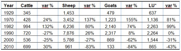
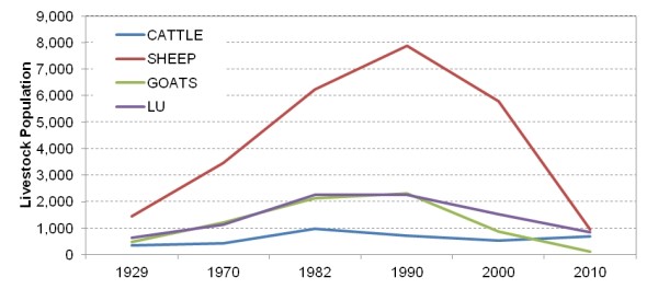
The principal source of income for local inhabitants remains agriculture and as such the local territory registers high levels of sheep and goat livestock farming and, to a lesser degree, cattle farming. Livestock composition has seen significant changes over the course of the last century. Data from the Agricultural Census shows that during 1970-1990 livestock numbers increased significantly, also in line with the increased standards of living and, consequently, the increase in pro capita buying power and demand for meat and dairy products. Nevertheless, mainly due to low competitive capacity of the Castelsaraceno livestock systems, also exacerbated by strictly enforced EU regulation, from the beginning of the 21st century, livestock numbers are in decline. The last decade shows a very dramatic reduction of livestock sector due to an accelerated dismantling in rural population. There has been an internal shift among different animal species (increase in the number of cattle which are less labor intensive and reduction of the number of sheep and goats that require more and continuous labor).
Vegetation – soil system
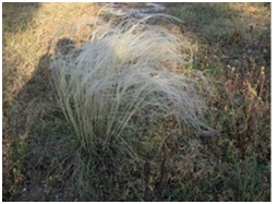
The “Piano dei campi” block shows well evolved and very deep soil, characterized by a powerful and reddish argillic (clayey) horizon. Soils in the block have loamy topsoil and a clayey-loamy soil in depth with coarse fragment ranging from common to abundant. They have moderately high permeability and good drainage. The dominant species is the Stipa austroitalica. The “Mount Alpi” block soils are loamy with umbric epipedon and variable coarse fraction content. Soils in the block show a loamy texture and a coarse fraction ranging from scarce to frequent. They are not calcareous and their pH is sub-acid on the surface and acid in the depth. The permeability is low and the drainage is good. The dominant species is the Stipa austroitalica. The “Favino” block includes deep clay and calcareous soils, with frequent coarse fraction on the surface and abundant in depth. Their permeability is low and drainage is good. They have derived mainly from the alteration of clayey marls (argillaceous marls). The dominant species is the Brachypodium rupestre. In degraded plots vegetation significantly changes, due to mismanagement of pasture. These ecosystems are characterized by lower presence and reduced quality of dominant species together with the disappearance of shrubs. This trend is observed in all three blocks regardless of their general but not substantial difference in soil parameters.
Socioeconomic status
The Basilicata region’s abundance of rural features is ascribable to its geographic positioning in relation to the largest hubs of socio-economic activity. In fact the area’s orography, together with its limited resources for agricultural activities, the lack of sustainable resources management (especially for forests), the isolation in which the area existed for many years and the diffusion of hydro-geological instabilities have produced a state of high environmental fragility in the region. The rural economy has for centuries been the pillar of the local economy and the principal source of income for the population. However, over the last few decades the local identity has undergone significant transformation, a sign of an invisible break between local people and their territory. Castelsaraceno is a small rural community characterized by small farms. Scarce local resources make profitability very low in the agricultural sector which is affected by a structural weakness at a local level. Livestock farming is widespread in all local farms with small number of animals managed by family run businesses. The most common livestock reared are cattle, sheep and goats, given that the production and processing of milk is probably the most important agricultural activity in economic terms. The most common form of feeding livestock remains grazing which, as discussed previously, is often carried our without a rational use of the natural resources available, thereby causing serious damage to local sources of fodder crops. Shortcomings in the livestock farming sector in the local area can also be traced back to the advanced age of most local farmers, as well as their low levels of formal education. Moreover, problems arise from the fragmented structure of land, which does not facilitate the supply of food which the cattle need. Local sheep and goat meat is sold, usually by weight, to local traders or directly from farmer to consumers. The periods of greatest demand obviously coincide with holidays such as Christmas and Easter. Local milk is processed directly on farm and cow and goat milk is usually milked manually.
Timeline of events
A brief event timeline of the most important changes and milestones that occurred in the natural and social environment of Castelsaraceno is shown below.
Main Causes of Land Degradation
Human induced Drivers
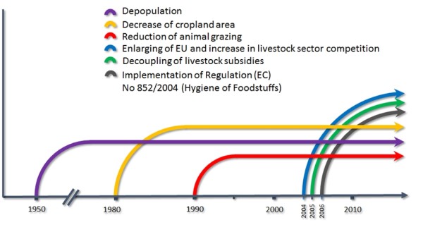
Removal of natural vegetation, deforestation: The Castelsaraceno Study Site has been inhabited since prehistoric times. Towards the end of the 8th century B.C. the arrival of the ancient Greeks in the region brought significant changes. The local area was re-organised around more sophisticated farming models, characterised by the division of land into small parcels, seen particularly on terraced land. The great agricultural expansion led to the beginning of deforestation with the now bare clayey slopes being subject intense erosion, which gave way to the first (calanchi) badland formations. Under Roman rule, large land estates prevailed, huge areas of the site were put to pasture and the systems of mono-cropping impoverished the soil and aggravated problems of erosion. In the 10th-11th century, the Byzantines and the Benedictine monks settled in the area due to its wealth of water sources and woodlands but carried out extensive deforestation in order to provide themselves with sufficient land for cereals crops, olive groves and grapevines. The Napoleonic reign (1805-1814) saw a more intense landuse with increased deforestation and a further expansion in agricultural land which caused a severe aggravation of hydro-geological instabilities and the loss of fertility of soil on the slopes with serious negative impacts on sheep-farming which had been the most important activity in the region. The deforestation in highland areas also affected the water courses thus resulting in extensive areas of swampy marshland at the river’s mouth. Nevertheless, the extension of arable crop land co-existed with the conservation of livestock farming and sheep farming. Aristocratic land owners did, in fact, intensify the breeding of wild animals and resident species, set aside land for grazing and built permanent structures to house animals, while still extending arable farming practices. Even after the abolition of feudalism the large livestock famers continued to use state woods and pastures and integrated the use of arable land with trees in order to make a double income from the fruit of the crops and the trees, used as feed in pig farming. Subsequent legislation impeded deforestation by uprooting legalised the cutting of trees.
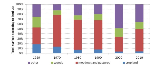
Land management: The agricultural census for 2010 shows Castelsaraceno to have a total area of 7,400 ha. The total number of 111 farms is a reduction of around 71% compared to 2000 (386 farms). Castelsaraceno is following the same trend in reducing farm numbers that is seen in the primary sector all over Italy. The most prevalent land use in the study site is currently meadows and permanent pastures, which make up around 70% of the Utilized Agricultural Area (UAA), whilst only 6% of land is used for arable crops. Around 80% of land in the local territory is common land owned by public bodies. These areas are generally public forests, pasture land, wooded areas, abandoned agriculture land, etc. An analysis of current legislation shows that town councils often fail to sustainably manage these land assets, with large areas in a state of abandonment or under an administrative role which leans towards a patrimonial management of lands. The first law regulating the division of state lands dates back to 1807. The law gave municipalities the control of the land and inhabitants lost their rights. In the mountainous parts of the study area shepherds left their sheep to graze on unkept land, whereas in woodlands a sort of levy was imposed for the right to use the common land.
With regional law no. 322/1928, collectively owned lands were again re-structured and plans for re-forestation and better land management on the part of local administrations were introduced. However, the lengthy administrative process surrounding checks, favoured the unlawful occupation of lands by private individuals and led to the destruction of more forested areas and pastures. The poor management of collective lands led to the gradual reduction in utilisable surface area. In the 1960s and 1970s intervention began to restore collective pasturage in the south of Italy. To this end, rural houses, shelters and fencing were constructed, nevertheless with disappointing results that left new infrastructures abandoned.
Common lands only re-entered a framework of environmental safeguards and valorisation of agro-silvo-pastoral activities and local natural and human resources with Mountain Law no 97/1993 which authorised the regions to legislate in land management issues in the wider context of rural development. The Basilicata region regulated collective land management with law no. 42/1998 which entrusted third parties (farming and forestry cooperatives, individual farmers and farming associations, public and private consortiums) with the management of goods and/or services including the use of pasture on public owned land with wooded/grass cover. The law set out that the state body in ownership of grazing land would issue a card granting permission to farmers wishing to graze their animals on common lands, taking into careful consideration the maximum number of animals grazing that the specific land area could sustainably support. The applications for pasturage are annually forwarded to the state body in ownership of the land stating the precise area under application, the number of animals to be grazing per species and also general details of the applicant farmer’s activities. The responsible body then evaluates the maximum capacity for grazing of the site and denies or issues permission for grazing. The capacity of grazing livestock, expressed in Livestock Units (LU), for each area must take into account the current state of the grass cover. Pasturage of goats is permitted only on bare pasture land or on shrub land and in high-stand woodlands. Pasturage is forbidden on newly planted woodlands, woodlands under renovation or affected by fire. In the latter case pasturage is forbidden for at least one year after the fire. It is the responsibility of the farmer to supervise his livestock during grazing and un-supervised grazing is only permitted in fenced areas. Fires are not allowed in woods, and farmers must be vigilant to any fire risks and report any incidents immediately. Grazing land cannot be crossed by roads or lanes.
Grazing management: The Town Council of Castelsaraceno also set out regulations for grazing on common land in 1949 which changed the previous 6 to 12 months period of concession to a three month period. In reality the regulation was scarcely applied and from 1970 to 1991 as successive local administrations in Castelsaraceno failed to apply any regulations at all. Since 1991 pasturage regulations were re-introduced. Nevertheless, evidence shows that there has not been any type of checks or controls in place in this period on the number of livestock allowed to graze on the entire surface area of all municipal pasture land. Consequently, these lands were used un-evenly with areas characterised by reduced grazing pressure, where real grazing is lower than the potential estimated capacity through grazing methodologies.
In 1999 Castelsaraceno Town Council passed deliberation no. 40 of 10/12/1999, in consideration of EC Reg. 207/92 (relating to methods of agricultural production compatible with environmental conservation and preservation of natural areas), which set out new regulations for pasturage on common lands. The regulation introduced several new elements: early pasturage applications to the Municipality should specify the locality under application, the period of grazing, number of animals per species and general details of applicant farmers. These factors along with maximum grazing capacity of each site are carefully considered before authorizing exploitation. Evidence shows that after this deliberation, Municipal management of pasture land allowed only part of municipal pastures to be used by private individuals. In reality this did not help improve the situation of pasture lands in the study area, which had been in a state of gradual degradation since previous decades because of the absence of an effective system of regulation for use of common pastures and grazing capacities. Today there are still cases of areas with overgrazing and lower grazing.
Natural Drivers
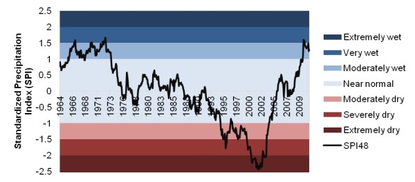
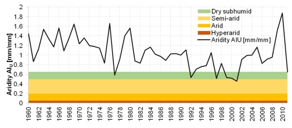
According to the data collected it seems that natural factors had little or no influence on pastures degradation in Castelsaraceno area. Nevertheless, the long term SPI index reveals that a drought spell in the 1990s could have increased pressure on the ecosystem. Regarding the Αridity Ιndex, the area displays little signs of weather related aridity or humidity deficiency. Nevertheless, a spell of decreased precipitation seems to briefly change this regime between 1990 and 2000, later to be corrected by wetter years after 2007.
Indirect causes
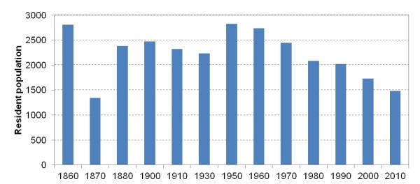
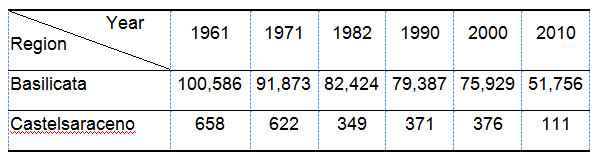
One of the greatest threats to the Castelsaraceno Study Site is depopulation. Negative demographic trends can play a key role in accelerating processes of degradation, causing reduced guardianship and increased abandonment of land which have serious environmental and cultural knock-on effects. Castelsaraceno, a township with a total surface area of 74.3 km2 had a population of 1,480 in 2010, that is 250 less that in the year 2000, 540 less than 1990 and a staggering 961 less than in 1980. The low population density which characterises the local area, around 20 inhabitants per km2 together with the depopulation trend, can be attributed to the area’s geographic position and difficult morphology as well as its severe lack of infrastructure. The township’s geographical isolation has inevitably affected the mind-set of the local people, who, while showing a strong sense of belonging to their town, struggle to form a collective identity which hinders the process of territorial cohesion that is essential for the implementation of any processes of development. The depopulation of the area is mainly caused by the out-migration of young people, often the most educated, who look for a way out from the difficult conditions in which the community lives. More specifically, the closure or reduction of schools, health centres, post offices, shops and the generally poor economy, are the factors that mostly affect migration towards larger, more economically active urban centers.
European agricultural policy is another factor that has impacted farms and conditioned the dynamic of livestock numbers and, consequently, the management of grazing. The first signs have been the application of the EEC Reg. 2078/92 and 2079/92 (confirmed also in the programming periods 2000-2006 and 2007-2013, together with measure 3.1 on organic farming). The entry into force on 1 January 2006 of the "Hygiene Package" (application of the EC Regulations n. 852/2004, 853/2004, 2073/2005, 2074/2005, 2075/2005 and 2076/2005) has permanently changed the EC rules on hygiene and official controls of foodstuffs. In this way, all Member States have the same criteria on the hygiene of food production and therefore hygiene checks are carried out according to the same standards throughout the European Community. Standardizing health standards has made the free movement of food products that are guaranteed as safe possible, which is a great benefit to consumers. However, the legislation has also introduced a series of stringent requirements for the livestock sector in rural areas which has resulted in a considerable number of producers leaving the sector, thus leading to huge reduction of farm units both at Castelsaraceno and Basilicata in the last decades. Furthermore, considering the fact that the farms present are generally small, family-run farms based on traditional farming models which are not capable of supporting the rising costs of production and administrative and bureaucratic costs to comply with the new rules. The most common complaint among problems highlighted by local stakeholders is the cost of meeting hygiene standards (which amount to between 1,000 and 6,000 euro per year) that leads to the ceasing of many crop and livestock farmers.