| Authors: | Tsanis, I. K. and Daliakopoulos, I. N. |
| Editor: | Jane Brandt |
| Source document: | Daliakopoulos, I. and Tsanis, I. (eds) 2014. Historical evolution of dryland ecosystems. CASCADE Project Deliverable 2.1. CASCADE Report 04. 126 pp. |
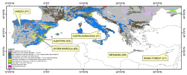
Study site descriptions
| Study site | Area (km²) | Annual rain (mm) | Average elevation m.a.s.l. | Pop. density (persons /km²) |
Main ecosystems | Main ecosystem services | Indications for irreversible change & tipping points | Drivers of change |
| Várzea, Portugal | 400 | 1500 | 300 | < 100 | Managed forests (90%) | Wood and biomass production, water resources, flooding control | Shallow soils, extensive stone lags, slow and contracted vegetation recovery after fire | Wildfire frequency and severity, post-fire land management |
| Albatera, Spain | 300 | 286 | 150 - 500 | 150 | Semiarid Mediterranean shrublands | Recreational use, marginal grazing, wildlife habitat | Loss of ecosystem functions, very low plant cover, altered landscape patterns, flooding | Synergetic effect of past exploitation and management with harsh environmental conditions, infrastructure |
| Ayora, Spain | 1000 | 350 - 700 | 600 - 900 | 100 | Shrubland, pine woodland, abandoned cropland | Regulating water and erosion, cultural (tourism), forest products (timber & non-timber), habitat | Changed composition vegetation, decreased ecosystem resilience | Increased fire incidence |
| Castelsaraceno, Italy | 74.3 | 400 - 600 | 700 - 1900 | 25 | Rangeland (>40%) | Rangelands support a large livestock industry (sheep and goats mainly), accommodate important watershed functions and provide valuable and biologically diverse resources | Desiccation of pastures due to changing climate and the substitution of pasture with shrubs and woods | Population decrease, land abandonment, poor infrastructure and social services, failure in reaching niche markets, increasing employment outside pastoral sector, shepherd lifestyle not attractive |
| Messara, Greece | 611 | 400 - 1100 | 50 - 2450 | 65 | Cultivation (40%), livestock | Water resources, agriculture, grazing, tourism | Drop in groundwater level, drying up of springs and wetlands with associated species loss, pollution with garbage, seawater intrusion | Growth of agriculture, uncontrolled groundwater exploitation, oversized dams, overgrazing, waste dumping |
| Randi Forest, Cyprus | 30 | 425 | 5 - 15 | 200 | Irrigated agriculture | Agricultural production, tourism | Decreased number of species | Development, economy |
Topography
The CASCADE study sites have a similar topography, mostly clustered around elevations of 400-700 m. Castelsaraceno is at the highest altitude and Randi Forest is closer to sea level.
Geology
There is also some uniformity in the geology and soils of the study sites. In Albatera, Ayora, Messara and Randi Forest soils are mostly shallow due to centuries of agricultural exploitation, subsequent abandonment and erosion. These shallow profiles also consist of calcaric material which does not promote vegetation growth.
Land use
In all study sites the dominant land use is open space with scrubland and/or herbaceous vegetation associations, sometimes with various degrees of transitions between forest and shrubland. Forest cover is highest in Várzea and Ayora and agriculture is in some cases also present at the margin of the sites. In all cases, the main ecosystem services are related to shrubs with some degree of natural or introduced forest vegetation (mainly pine trees, Maritime, Aleppo, etc.). Ecosystem value includes provisioning, supporting, regulating and cultural services in the diverse blend that makes Mediterranean regions so unique. It is noteworthy that although study sites are part of the natural environment, their adjacent landscapes have been transformed to a degree by human input, as is the case in most Mediterranean regions. This input, such as marginal agriculture, the introduction of grazers, and deforestation has often been negative but has also formed the unique ecological character of these regions.
Climate
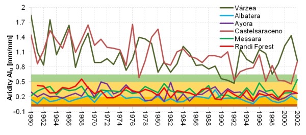
Climatic conditions cover a wide range, with a long term minimum average annual precipitation found in Albatera (267 mm) and maximum average annual values at Várzea (1,170 mm) and Castelsaraceno (1,290 mm). In the latter, high precipitation values are obviously linked to the higher elevation. The rest of the study sites receive around 450 mm of precipitation. The lowest average annual temperatures are observed in Várzea (13 ºC) and Castelsaraceno (9 ºC) with the rest of the sites ranging between 17-18 ºC. The only exception is Randi Forest with an higher average annual temperature of 19.5 ºC. It is noteworthy that, in all sites, temperature appears to have been increasing over the past 40 years. This trend is less pronounced in the Eastern Mediterranean (Messara and Randi Forest) with a rise of 0.1 ºC per decade while in the rest of the sites temperature rises by 0.3 to 0.5 ºC per decade.
Among all study sites, Várzea and Castelsaraceno display the least signs of weather related aridity or humidity deficiency. In fact, their long term climatic conditions do not classify them as drylands. Nevertheless, they are both displaying clear trends to enter the dry-subhumid zone as the available 40-year records show a decrease in precipitation and a parallel increase in temperature. Both these sites are also seasonally dry and therefore suffer from drought-related problems. This factor, along with human induced drivers makes them susceptible to land degradation. The rest of the study sites are either semi-arid or arid with varying inter-annual behaviour that, in some cases, approaches hyper-arid conditions. Taking into account the uniformly positive temperature trends that appear to agree with climate change scenarios, there is a high probability that these conditions will continue in the years to come.
Vegetation cover
NDVI analysis reveals that by far the poorest vegetation state can be found in the Randi Forest, followed by Albatera and Messara. In contrast, Castelsaraceno and Várzea seem to be at a better state over the long-term. Castelsaraceno also shows the highest NDVI fluctuation, possibly due to the effect of altitude, followed by Messara and Randi Forest.
- Várzea oscillates around a mean NDVI of 0.548, with an absolute maximum of 0.653 and an absolute minimum of 0.366. On average the highest vegetation activity can be observed in July and June and the lowest in December and January.
- In Albatera, the average NDVI is 0.184 with a seasonal high during the winter and spring months (December to April) with an absolute peak in March. The seasonal low is during the summer months (June to August) at an almost equal distribution. Albatera and Ayora show very small inter-annual fluctuations in NDVI, with summer months presenting the smallest chlorophyll activity and an average of 0.381.
- In contrast, in Castelsaraceno, the monthly fluctuation is well differentiated with increased summer NDVI values and lower activity during winter. The highest NDVI value is observer during June (record median around 0.65) but the same month also displays a high level of uncertainty which signifies the instability of the variable.
- Messara Study Site also displays a well depicted difference between seasons. Nevertheless, instead of an increasing NDVI during summer months, like in Castelsaraceno and Várzea, the fluctuation of observations shows more similarities with the cases of Albatera and Ayora. February shows the highest values with an annual median of 0.48 while the long term average in the area is 0.35.
- In Randi Forest, summers can indeed be very harsh, sometimes reducing vegetation activity to zero from June to August. February and March are the most favorable months for vegetation, with October and November showing on average steadily lower values of NDVI. This study site has the absolute lowest average NDVI (0.158).
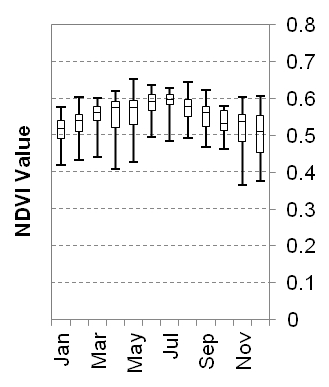
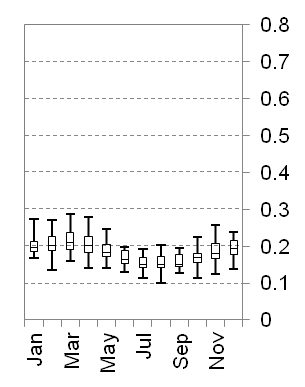
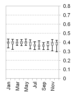
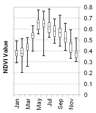
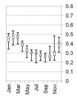
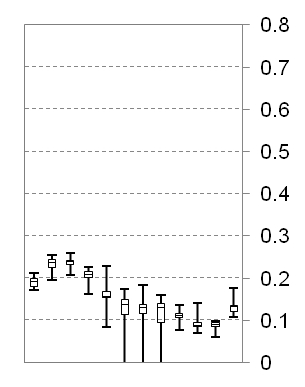
Table: NDVI statistics (mean and standard deviation) for the six CASCADE Study Sites.
| Site | Várzea | Albatera | Ayora | Castelsaraceno | Messara | Randi Forest |
| Mean NDVI | 0.548 | 0.184 | 0.381 | 0.514 | 0.350 | 0.158 |
| Stdev NDVI | 0.050 | 0.030 | 0.030 | 0.117 | 0.080 | 0.080 |
Remote sensing-derived vegetation indices have a high potential for assessing vegetation activity, as a result of both climatic and human induced drivers. Simply put, a continuously decreasing vegetation index over time is a sign of desertification. Combined with land cover/land form/rainfall information and calibrated on the ground with biomass measurements, NDVI can provide significant indications, even quantitative, on the different types of vegetation degradation (or restoration) and on the recurrent drought factor related to it. A general conclusion from the analysis of chlorophyll reflectance from satellite imagery is that all sites show only minor trends in the NDVI index, with the exception of Albatera where a strong correlation seems to exist. While this fact infers that these systems are still not under any long term distortion leading to extensive degradation, the scales that have been considered up to this point are rather coarse. Historical developments, as well as the current vegetation status, indicate that when certain thresholds are being approached, significant changes in NDVI can occur.
Socio-economic status
The socio-economic backgrounds of all study sites follow patterns similar to those seen in the desertification paradigm. The decline in a young population who are abandoning rural ways in favor of a more modern urban lifestyle, better education and employment opportunities is an ever-occurring feature. The remaining population is aging, often has considerable levels of illiteracy and thus limited resources for sustainable land, farm and animal management. Subsequent land abandonment patterns imply that the rural landscape presented, and may still present, fewer opportunities for work and livelihood, that fewer incentives have been given to balance the advantages of the urban lifestyle, or that these incentives and advantages have been poorly transmitted through dissemination channels, upbringing or formal education.
Land abandonment has resulted in the deterioration of what is perceived as the desirable ecological status and ecosystem services. Nevertheless, the responsibility of local or national managing authorities to mitigate natural and human induced perturbations, such as fuel load buildup, overgrazing and land use mismanagement is also great.
These conditions are often worsened by individual bad management decisions that may look profitable in the short term but have adverse long-term results for both the environment and livelihood of the community. For example, over-extraction of groundwater allows short term gains through irrigation, but can cause long-term damage to both the environment (e.g. drying up of wetlands) and the community (falling water levels, salinization problems). Droughts certainly increase various risks related to poor land management, such as fire hazard and groundwater depletion, thus accelerating the downward spiral of degradation and desertification.
In close relation to mismanagement, the impact of EU policy is more often seen as an adverse factor rather than an aid or a tool to improve product and production quality or the wellbeing of the ecosystem and the community. The crisis in traditional farming systems, accelerated by national and higher level agricultural policies, have been translated into the adoption of increasingly mechanized mass crop production and intensive farming practices which often prove inappropriate to local terrain. Rural areas have been hit by increasingly severe processes of degradation caused by intensive farming practices and changes in crop production, phenomena which are closely linked to the social and economic changes which continue to impact rural areas. The progressive decline in traditional agricultural practices due to the absence of adequate research and development of traditional agricultural techniques could, however, see a turn-around in current European agricultural policy whose objectives are not solely based on maximizing production but also very much on environmental protection and qualification of local products and local territories. Although not specifically mentioning Mediterranean states, the new EU CAP addresses strategic objectives particularly relevant to the region. The recent reform features a more flexible and fairer distribution of financial support while respecting local priorities. Moreover, the financial crisis now faced by many southern states may eventually present a significant part of the urban population with opportunities to escape poverty and unemployment through a decentralization wave towards the often more hospitable Mediterranean rural lifestyle.
Main causes of land degradation
At first glance, the main causes of degradation for each study site are different, but they are always relevant to the accumulated impact of a driver: forest fires, marginal agriculture, grazing and wood-gathering activities, and long-term poor land management that is difficult to overturn. Less often, the causes are related to climate, which nevertheless serves as a catalyst. This accumulated impact may be associated with the concept of sudden ecosystem shifts beyond thresholds that preclude successful restoration of the desirable ecosystem properties and services.
Sudden transitions have been shown to occur under continuous external stress, such as decreased water availability or increased grazing. Such changes have previously been documented in the transition of a green Sahara to its current desert state, but there is evidence similar changes can occur in the semi-arid Mediterranean as well. Furthermore, in cases where external pressure is discontinuous, such as wildfires, large erosion events caused by flood events, etc., sudden shifts can be anticipated. A relatively recent large scale example of discontinuous change in the Mediterranean is the deforestation of central Crete before the end of World War II. At smaller scales, similar phenomena are observed in restored Mediterranean forests that, after numerous fire occurrences, have lost resilience and subsequent restoration sensu latu is never finished, as some maintenance is always required.
In both systems, strong feedbacks between biotic factors and the physical environment can signify the existence of localized thresholds. These thresholds can either depict a "point of no return" or a "resilience against restoration" owing to constrains or in the vegetation-soil system at landscape level. Whereas for continuous pressure, thresholds may be sought in the combined effect of a secondary pressure, in the case of discontinuous events, thresholds relevant to event frequency and intensity are possible key indicators. These thresholds are often associated with target species physiology, landscape and climatic characteristics and can be expected to have a localized effectiveness, although, emerging patterns can potentially evolve into a unifying framework.