| Authors: | Alejandro Valdecantos and Ramón Vallejo (CEAM) with input from study sites |
| Editor: | Jane Brandt |
| Source document: | Valdecantos & Vallejo. (2015) Report on structural and functional changes associated to regime shifts in Mediterranean dryland ecosystems. CASCADE Project Deliverable 5.1. |
An area under pressure from fire
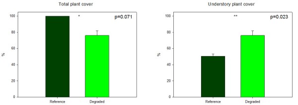
Total plant cover in Várzea field site was, obviously, significantly lower in the 4-times burned state than in the reference forest. The Reference pine forests showed canopy closure and, hence, 100% plant cover while the four times burned sites showed 76.1% of plant cover just two years after the last fire. Removing trees from the analysis, the cover of the herbaceous and shrub layers was significantly higher in the Degraded state than in the Reference associated to the reduction of light reaching the soil in the former and the natural secondary succession dynamics in the latter.
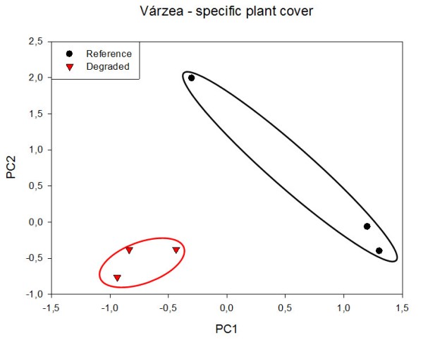
The most represented species in the understory of the Reference ecosystem are Ulex minor, Agrostis curtisii and Pteridium aquilinum with 15.4, 14.3 and 9.6% of specific plant cover, respectively. The Degraded state showed, as mentioned above, higher development in the understory layer due to the removal of the tree layer and the short time elapsed since the fire. Agrostis curtisii, Pterospartum tridentatum and Erica umbellata averaged 45.8, 35.5 and 25.9% of specific plant cover, respectively. Only six species appeared in the Degraded state, four of them were common with the Reference state. The PCA analysis conducted on specific plant cover data of the understory showed a clear separation of Reference and Degraded plots, especially according to the first axis records (46.5% of variance explained. Four species showed high positive eigenvalues on this axis: U. minor, Arrhenatherum sp., P. aquilinum and P. pinaster (0.971, 0.971, 0.945 and 0.919, respectively). Of these species, only U. minor and P. aquilinum are abundant in two out of three replicated Reference plots, and the other species represent less than 1% of plant cover. The three Degraded plots showed negative values of PC1, associated to high cover of P. tridentatum and A. curtisii (eigenvalues -0.857 and -0.719, respectively). One of the Reference plots showed different plant cover than the others, both Reference and Degraded, with very positive values of PC2 (20.3% variance explained) associated to high cover of Simethis mattiazzi, the presence of E. umbellata and low cover of P. tridentatum (eigenvalues 0.978, 0.936 and -0.562, respectively). This could be related to different fuel management strategies affecting the understory vegetation.
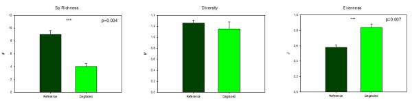
The number of plant species was also significantly lower in the Degraded than in the Reference sites, with a reduction of more than 50% of species richness due to fire (recurrence and time since the last one). The Shannon-Wiener index of diversity (H) did not show significant differences between states with total values around 1.2. However, the Degraded sites showed significantly higher evenness values than the Reference state (0.84 vs 0.58, respectively) suggesting that plant individuals in the Degraded areas are more evenly distributed than in the understory of the Reference sites.
Interpatches in reference plots were covered by pine litter and cryptogams. In the degraded plots, interpatch was bare soil with stones and remains of ashes and charcoal.
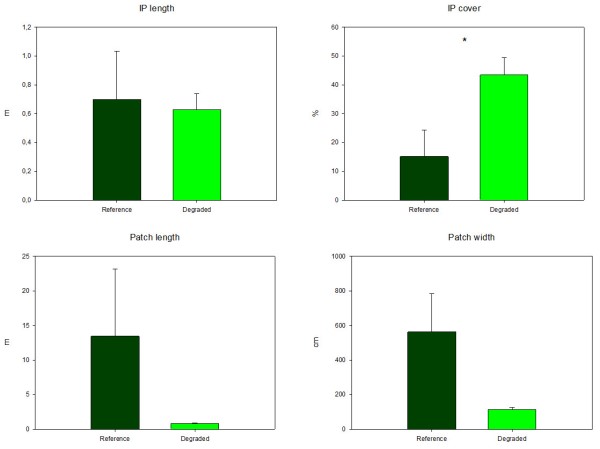
The Degraded and Reference states differed significantly in the percentage of ground that corresponded to interpatches, amounting to 43.4 and 15.2%, respectively, but not in interpatch length. The size of the vegetated patches was also larger in the Reference state, with an average of 13.5 m in length and 5.6 m in width, as compared to the Degraded state (0.8 m long and 1.1 m wide).
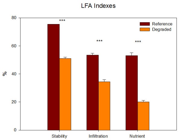
All three indexes derived from the LFA, stability, infiltration and nutrient cycling, were significantly reduced in the Degraded state. The sharpest reduction was observed in the nutrient cycling index which dropped from 53.1% in the Reference to 20.1% in the Degraded. The infiltration index in the Reference showed a value of 53.4% and only 34.4%in the Degraded. Similar decrease was observed in the stability index, from 75.4% in the mature pine forest to 51.1% in the four times burned sites.
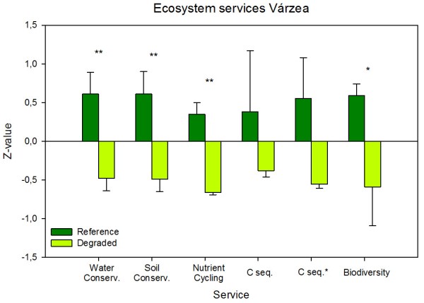
Most ecosystem services derived from these variables experienced a significant decrease due to recurrent fire. In the case of C sequestration, only the understory biomass has been quantified in the assessment. Using available data of biomass of the overstory layer of Pinus pinaster forests (110.2 Mg ha-¹), the loss of C sequestration service is increased. The remaining services, soil and water conservation, nutrient cycling and biodiversity, showed similar losses due to recurrent fires. The combination of all standardized ecosystem services in Várzea showed a significant decrease in the Degraded sites in relation to the Reference sites suggesting a global loss of ecosystem services.
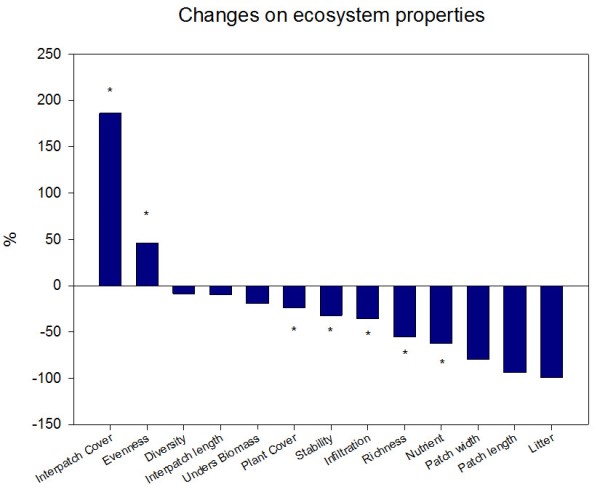
All the observed changes between the Degraded and the Reference states, except evenness, decrease in the four times burned sites, suggesting important losses of these characteristics. Note that positive values of interpatch cover represent larger areas of bare soil, stones and, in general, without woody vegetation.
Note: For an overview of the structural and functional changes and their analysis in all study sites see »Structural and functional changes.