| Authors: | Keizer, J. J. and Valente, S. |
| Coordinating authors: | Tsanis, I. K. and Daliakopoulos, I. N. |
| Editor: | Brandt, C. J. |
| Source document: | Daliakopoulos, I. and Tsanis, I. (eds) 2014. Historical evolution of dryland ecosystems. CASCADE Project Deliverable 2.1. CASCADE Report 04. 126 pp. |
Description of the study site
Location
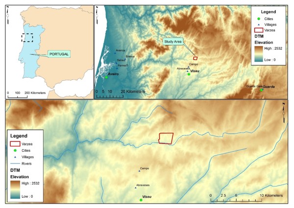
The Várzea Study Site is located in north-central Portugal and encompasses an area of some 30 km², part of which was burnt by a wildfire during early September 2012. The burnt area covers seven local administrative areas or “freguesias”, all of which are in the Viseu municipality and district. Three of the freguesias, Calde, Cepões and Lordosa were clearly most affected by the fire, and the CASCADE experimental plots are all located in Calde.
Topography
Várzea is part of the Hesperic Massif and, more specifically, the Central Iberian Zone. It is located in the foothills of the Montemuro mountain complex, at elevations between 450 and 600 m. The site is dissected by a series of small watersheds that have an overall south (- western) drainage direction towards the Vouga river. The basin of the Vouga lies completely in Portugal, has a total length of 136 km and drains a total area of 3.700 km² before discharging into the coastal lagoon area of the Ria de Aveiro. The Vouga is an important source of drinking water for the downstream municipalities, through the Carvoeiro water capture station, and will be an important source of hydro-electric energy from the Ribeiradio-Ermida dam complex that is currently under construction.
Geology and soils
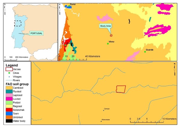
As part of the Hesperic Massif, the Várzea study site and surroundings are dominated by pre-Ordovician schists and greywackes, and Hercynian granites. The nine experimental plots are underlain by schists or, most probably, greywackes, rather than granites. The soils are predominantly Cambisols consisting of mollic soil material.
Land Use
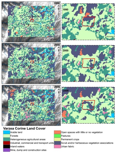
Land cover in Vázea is typical of large parts of the interior of north-Central Portugal. Over the last two decades the predominant cover has been forests and shrublands and, to a lesser extent, heterogeneous agricultural areas. Between 1990 and 2006 there was little to no change in the agricultural areas, but a noticeable transition between forest and shrubland. In the first decade forests expanded then shifted back to shrublands between 2000 and 2006. Wildfires in 1985 and again in 2005 are probably the reason behind these transitions. The forests consist predominantly of mono-specific stands of Maritime Pine (Pinus pinaster Ait.). Although Maritime Pine is a (western) Mediterranean species, its present-day widespread occurrence is, as in the rest of Portugal, due to planting. In the wider region, extensive planting of public forest with Maritime Pine took place in particular during the late 1940s and early 1950s.
Climate
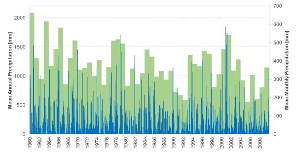
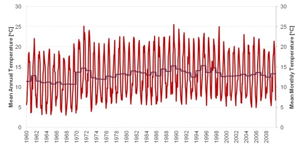
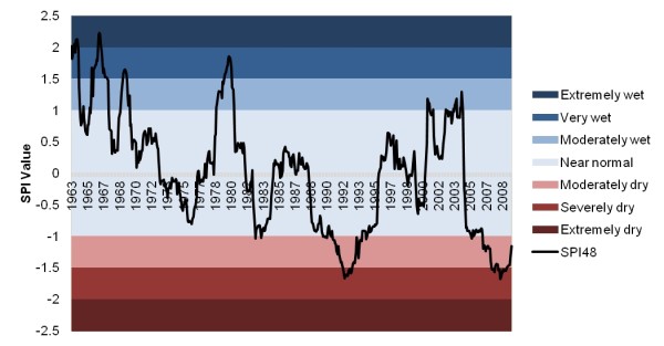
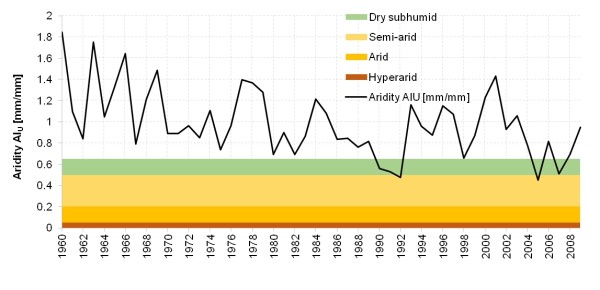
The climate is humid meso-thermal with a prolonged dry and warm. It is during these dry and warm summers that the majority of wildfires occur. Rainfall varies strongly, not only seasonally but also inter-annually, as is typical for Mediterranean-type climate regions. At Sátão, the nearest rainfall station to the Várzea Study Site, annual rainfall during the period 1960-2009 varied between 550 and 2080 mm, with an average of 1170 mm. Rainfall is sometimes very intensive. Air temperature reveals a pronounced seasonal variation. At Viseu, the nearest climate station to the Várzea Study Site mean monthly temperatures during the period 1960-2009 ranged from 6.3 °C in January to 20.5 °C in July, with minimum and maximum monthly temperatures of 3.1 °C (December 1967) and 25.5 °C (July 1989). Ten of the 13 coldest months occurred before January 1973 after which there seems to be a warming trend.
Main Ecosystems
Field observations suggest that the understory of the nine Maritime Pine stands is principally (a) the shrubs Erica australis L., Calluna vulgaris (I.) Hull and Pterospartum tridentatum (L.) Willk (b) the herbs Scilla monophyllos Link and Simethis mattiazzi Vandelli Sacc and (c) the grass Agrostis curtisii Kerguélen.
The vegetation-soil system includes forest stands exclusively or predominantly composed of Maritime Pine trees (Pinus pinaster Ait.). The trees in the nine experimental plots were planted and/or seeded (without apparent evidence of mechanical ground operations), or resulted from spontaneous re-sprouting following wildfire, possibly in combination with thinning activities. The understory vegetation appears to be spontaneous. Its floristic and structural composition probably reflects the presence and frequency of land-use practices such as fuel load removal and, more sporadically, goat grazing.
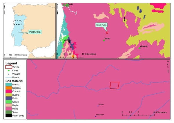
The soils in the experimental plots are all shallow, less than 40 cm deep, and derived from schists or, most probably, greywackes. Soil pits dug reveal profiles comprising A and B and/or BC soil horizons, together (in the unburnt plots) with a considerable litter layer (7-8 cm thick, Field classification points towards a mixture of umbric Leptosols, epileptic Umbrisols and humic Cambisols. Field assessment of the soil texture itself suggests a clear predominance of sandy loam soils.
Socio-economic status
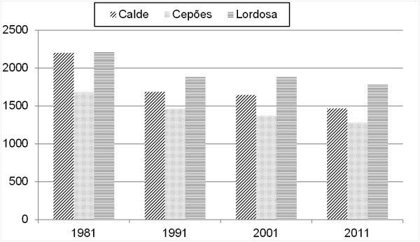
In line with the general tendency for population exodus from the rural inland Portugal, the three freguesias most affected by the 2012-wildfire (Calde, Cepões and Lordosa) have seen their resident populations decrease considerably (from 19 to 33%) over the past three decades with the decline steepest between 1981 and 1991. The high proportion of elderly people and the considerable levels of illiteracy (over 10% in 2011) are worth highlighting. Agro-forestry land-use activities had become of limited importance for employment by the time of the 2012 wildfire. In 2011, the primary sector employed from 10% to 20% of the active resident population, the majority of whom (60 to 70%) were employed by the tertiary sector.
Timeline of events
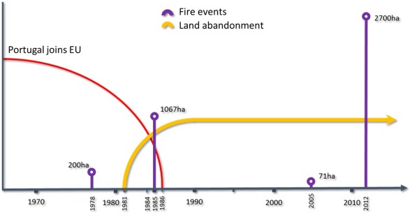
The timeline of the principal events is relatively straightforward, consisting of the four wildfires that occurred in 1978, 1985, 2005 and 2012. All of these happened during the summer season although the exact dates of the pre-2012 wildfires are still unknown. However, there are marked differences in the burnt areas between the four fires, with those of 1978 (200 ha) and 2005 (71 ha) being considerably milder than those of 1985 (1067 ha) and especially 2012 (roughly 2700 ha).
Main Causes of Land Degradation
Human induced Drivers
Forest fire is the main driver of land degradation in the Várzea area and is regarded in Portugal (as in the rest of the Mediterranean basin) as caused by human activity. Focus is given to the land degradation impacts of the wildfire which occurred in early September 2012. Preliminary assessments show that the effect of this recent event was of a different magnitude to the three previous wildfires.
Natural Drivers
Drought can influence wildfire-induced land degradation through factors such as ignition probability, fire spread and severity as well by affecting ecosystem recovery following fire. Prolonged spells of comparatively dry conditions were observed during the early 1990s as well as the late 2000s. Thus, drought could well have played a role in the occurrence and severity of the 2005-fire as well as in the subsequent recovery of the ecosystem.
Besides drought events, heavy/extreme rainfall can be of crucial importance for the land degradation impacts of wildfires. This is especially important during the initial stages of the “window of disturbance” following fire, when soils are most susceptible to be eroded by water.
Indirect causes
Land management can be an important indirect cause of land degradation associated with wildfire. In the wider study region, downslope rip-ploughing in a recently burnt area increased sediment losses to rates well beyond those immediately after fire. Post-fire logging can also increase soil erosion, especially if it leads to exposure of bare soil. Post-fire emergency treatments, such as mulching, that can effectively reduce soil losses in recently burnt areas are poorly established in Portugal.