| Authors: | Christoforou, M. and Tsaltas, D. |
| Coordinating authors: | Tsanis, I. K. and Daliakopoulos, I. N. |
| Editor: | Jane Brandt |
| Source document: | Daliakopoulos, I. and Tsanis, I. (eds) 2014. Historical evolution of dryland ecosystems. CASCADE Project Deliverable 2.1. CASCADE Report 04. 126 pp. |
Description of the study site
General information
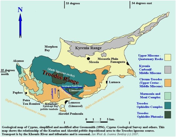
Cyprus is the third largest island in the Mediterranean, and is located in the South East Mediterranean, in the Levantine Basin, with an area of 9,250 km2. The island is dominated by two mountain ranges: Troodos, in the central and western part and Pentadaktylos in the north (Kyrenia range). The geological history is characterized by marine sedimentation in a sea that became gradually shallow. The climate is intense Mediterranean with an average annual rainfall of approximately 480 mm. The Pissouri area is located at the south zone of Cyprus, in the south east part of Paphos district area and consists of the Randi Forest (located in Pissouri basin), being characterized as drylands. Vegetation consists of plants from different habitats such as pine forests, phrygana, maquis, all growing around the rocky hill faces. In the Pissouri area, lack of rainfall leads to shallow soils and water erosion, while soils are further damaged by livestock grazing, thus impeding plant growth.
Topography
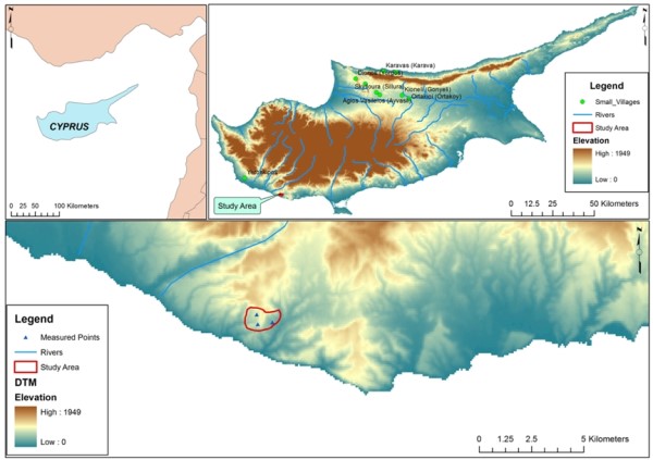
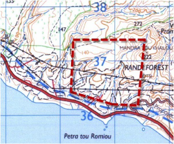
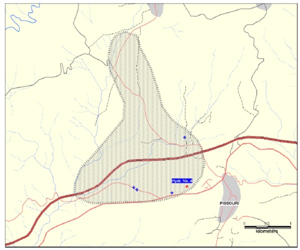
The topography of Cyprus is affected by the geology and dominated by the Troodos Mountains in the south and the Kyrenia Mountains along the northern coast and Mesaoria plain. The Randi Forest Study Site is approximately 14 km² with focus on three particular areas at 34°40.286N, 32°39.292E; 34°40.237N, 32°38.830E and 34°40.487'N, 32°38.797' E over an area of approximately 4 km² at an inclination of 20-25%. The topography ranges from 0 to 140 m above sea level. The sites include the three grazing conditions being examined by CASCADE.
Geology and Soils
The dominating soils in the area are calcaric regosols, with a deep brown color. The soil contains around 25% clay and 40% silt. In the valley and on hills there is a slight inclination of 20%. Deeper colluviums soils are also present with 30-40% clay and 50% silt. Many parts of the area are characterized by severe topsoil erosion losses and thus, the root system is limited by the underlying strata. Furthermore, the high CaCO3 content and the clay soils reduce the infiltration rates and thus increase water erosion.
Soil studies and classification began in Cyprus in 1957 and consisted of the physical and chemical data of soil properties. The majority of soils on Cyprus display near neutral to alkaline pH (>8) values, reflecting the influence of carbonates, as well as colluviums – alluvium areas and alkaline earth oxides and hydroxides derived from dominate formations. This is significantly more alkaline than the average for the rest of Europe (pH 5.5-5.8).
Land Use
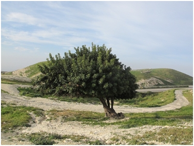
The sites consist of hilly terrain covered by open areas with shrubs and sparse carob and olive trees. Areas south of the forest consist of vineyards, which have dried up due to lack of water. As the land is not suitable for agriculture, it is used for livestock grazing, in particular goats and sheep. Besides recent events, the major land use change occurred in the 1930s, when Randi Forest was still an actual forest rather than the shrubland it currently is. When interviewing people in the village, two old men aged 87 and 85 years old said that “in the 1930s the British governor gave permission to the local people in the area to cut the trees and use them as firewood”.
Climate
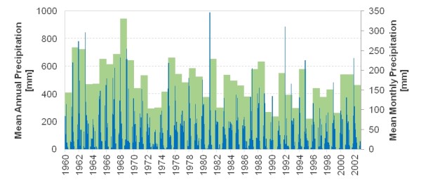
The climate in Cyprus is intense Mediterranean, with wet, variable winters from November to March, and hot, dry summers from May to September, separated by short spring and autumn seasons of rapidly changing weather. The average annual rainfall in the area was 410 mm from 1990 to 2000, and 440 mm from 1970 to 2000, below the 480 mm average for the island as a whole.. However, annual rainfall data from the Asprokremmos region near the Randi Forest indicates an average rainfall of 490 mm. Annual rainfall has decreased by almost 50%, from about 600 mm to about 330 mm, over the period 1960-2002.
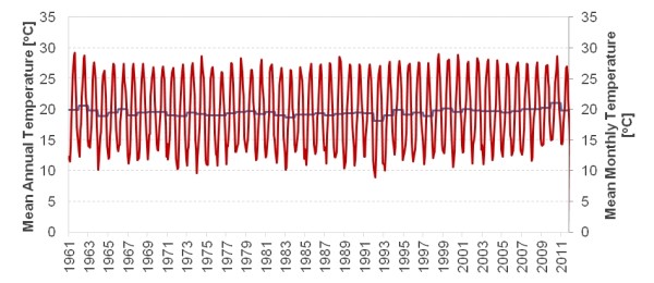
The average annual temperature in the area is 33°C during summer and 15°C during winter-time. Monthly temperature fluctuation in the area is relatively stable over the historical record with an annual average of 19.5 °C. In the study area, the average monthly evapotranspiration is 180 mm, with the potential evapotranspiration being 250 mm monthly. The potential evaporation in the area was estimated at 1,700 mm.
Hydrogeology
The period of zero precipitation lasts for four months, from July until October. There is no information available regarding the groundwater level and the flow/runoff. There is also no available information regarding the type and amount of irrigation water. The area is just outside the Pissouri West, located over a Gypsum Aquifer. In the last few years, the aquifer has gained more importance because of the reduction in the diverted quantities of surface water. The aquifer is outcropping in several places. Recharge depends on rainfall and, to a lesser degree, on return flow from irrigation. The aquifer has yet to be studied in depth. The groundwater in this aquifer is supposed to always be saturated in sulfate ions (SO4--) the concentration ranging between 1400 and 1,500 mg/l which is beyond EU limits for drinking water (250 mg/l) but within the limits for irrigation (250 to 3,000 mg/l).
Main ecosystems
Cyprus is a Mediterranean island, biogeographically isolated from the three regional continents and therefore the plant and animal species have evolved into endemic species. During the Neolithic and Chalcolithic eras, several species of large mammals (hippopotami and elephants) and alien plant species were introduced to the island. Cyprus is considered as a biodiversity “hotspot” area as it is the only center of birds’ endemism in Europe and the Middle East.
Flora
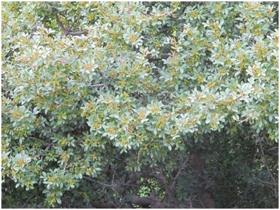
The Cyprus flora includes in total 1,910 taxa that are native or naturalized, among of which 143 are endemic. The percentage of endemics can reach over 20% within the Troodos mountains, where large numbers of endemic plants such as the cedar (Cedrus brevifolia) and the golden oak (Quercus alnifolia) grow. The varied microclimate and geology is the main reason for the high number of endemic species.
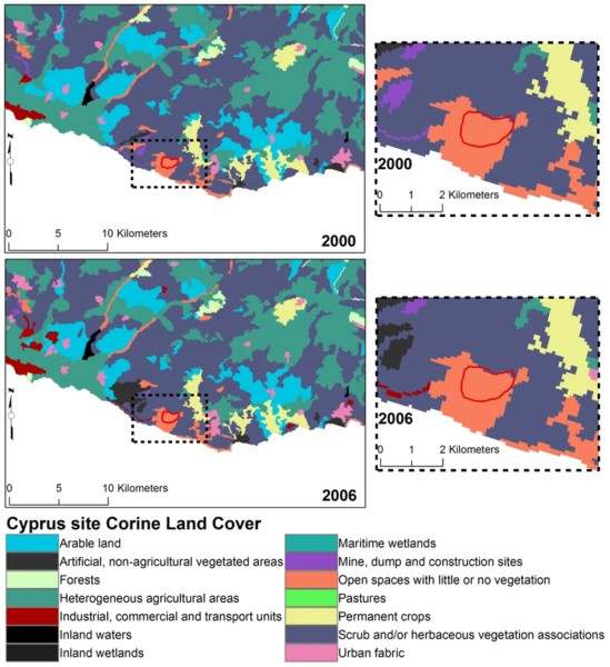
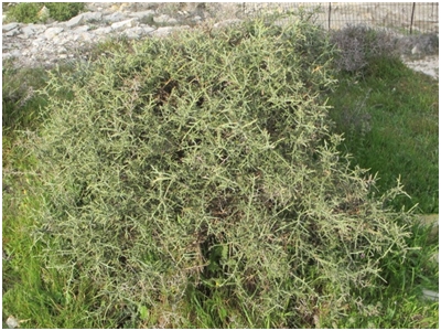
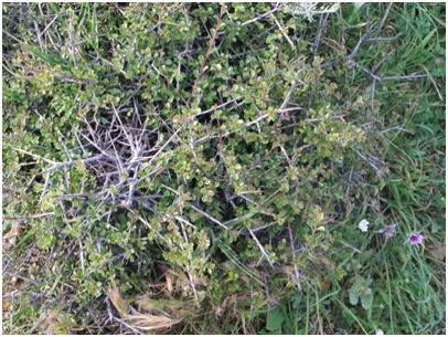
In the study site, the natural landscape is dominated by scrublands, the typical Mediterranean maquis, Garigue and Phrygana. This landscape has been formed by man-made activities such as forest destruction with subsequent periodic burning and overgrazing, followed by soil erosion. Where soil is not significantly eroded and factors such as slope, aspect and moisture are favorable, succession follows from phrygana to garigue and finally to maquis. Most of the shrubs are sclerophyllous of varied heights such as Calycotome villosa, Genista fasselata and Rhamnus oleoides. Trees are scattered in the area and consist mainly of Olea europaea, Ceratonia siliqua and Pinus species. The Bromus and Malva species are found among the shrubs and tree grasslands. For the purpose of the CASCADE project, plants in the area of interest were identified using the natural key system which is based on morphological characteristics such as structures of stems, roots and leaves, embryology and flowers. Plant parts were collected and photographed from an area of 50 ha.
In total, 57 species were identified within the study site. Various types of shrub communities dominate in the thermo-Mediterranean semi-arid zones. It is a typical coastal zone with dry grasslands, shrubs and forest openings. Trees, shrubs and grass were observed among the species, where the most dominant ones in the area were Olea europaea, Calycotome villosa, Cistus parviflorus, Genista fasselata, Sinapis alba, Malva sylvestris and wild poaceae species. Eighteen plant families were observed (Anacardiaceae, Apiaceae, Asteraceae, Cistaceae, Compositae, Ericaceae, Fabaceae, Lamiaceae, Malvaceae, Oleaceae, Papillionacea, Pinaceae, Poaceae, Ranumculaceae, Rosaceae, Rubiaceae, Urticaceae and Zygophyllaceae).
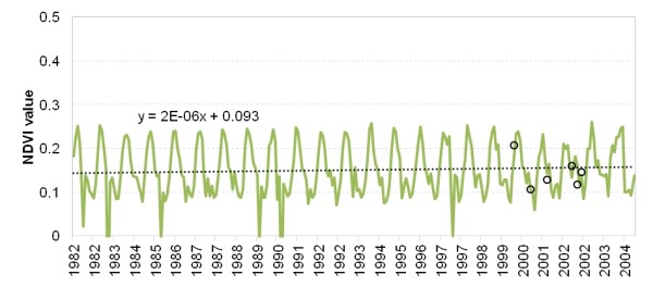
A synoptic view of vegetation health and the associated function of ecosystems can be derived from analysis of archival and on-going sequences of NDVI. New estimations from LandSat imagery (black circles) at the exact locations of the study site were used to correct the global dataset for bias. NDVI in the study area shows no significant trend since the 1980s. Nevertheless, NDVI values are significantly low.
Fauna
Cyprus contains diverse fauna due to the fact that the island is at the crossroads of three continents and there is a wide range of habitats present on the island. The fauna includes endemic species of mammals, snakes and birds. The island is considered to be an important endemic region for birds from all over the world, while it constitutes one from the 8 most important migratory routes for the birds in Europe. Nine mammal species are included in the Annex of II Directive 92/43, and in particular one as priority. Two mammals are included in the Annex I of the Habitat Directive i.e. the Cyprus muflon (Ovis orientalis ophion) and fruitbat Rousettus aegyptiacus. More than 385 species of birds have been recorded in Cyprus, 53 as permanent residents and the rest as migratory. Twenty-four species of reptiles and 3 species of amphibians are documented. Four endemic subspecies of lizards and two endemic species of snake are reported, as well as two endemic subspecies. The Cypriot snake Coluber cypriensis and the grass snake Natrix natrix cypriaca are both endemic species of reptiles. The Cyprus snake Coluber cypriensis was added in Annexes II and IV of Directive 92/43/EEC, as priority species. It has been characterized as endangered (EN) by IUCN as the threats for this species increase mainly due to human activities and fires.
In the study site, fauna consists of birds, mammals, insects and reptiles. Birds include the species Αlectoris chukar, Coturnix coturnix, Tyto alba, Streptopelia turtur and Pica pica. Insects include Lepidoptera, Hemiptera, Orthoptera and Coleoptera. Mammals like Lepus capensis, Hemiechinus aurithus and Vulpes vulpes where observed during a night visit. Within the category of mammals, goats and sheep are included as domesticated and not wild animals.
Vegetation – soil system
In the study site, the main vegetation is consisted of Phrygana, mostly Calycotome villosa, Genista fasselata and Rhamnus oleoides. The selected plant for monitoring is R. oleoides which is the most common and at the same time, uniform in terms of shape and size.
Timeline of events
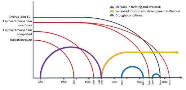
The brief event timeline shows the most important changes and milestones that occurred in the natural and social environment of Cyprus and the Randi Forest area.
Socio-economic status
Pissouri has experienced continuous population growth. In 1881 there were 482, inhabitants, increasing to 956 in 1931, 1,072 in 1960, and 1,030 in 2973. The current permanent population in the Pissouri area is approximately 1,400 people, about half of whom are Cypriots and half of whom are expatriates, primarily from the United Kingdom.
Pissouri was a very traditional agricultural village, producing grapes, wine, potatoes and citrus fruits. There are also many olive, carob and almond trees in the area. Livestock grazing, especially sheep and goats, was also common. However, in recent years, farmers had to eradicate big part of their vineyards, as they became unprofitable and, instead, focused on housing development and the tourist industry in the south part of the village. This has led to a significant decline in the agricultural sector. The livestock sector was moved to the northwest area of Pissouri, which is where the study site is located.
Main Causes of Land Degradation
Human induced Drivers
Historically, the study area was predominately used for agriculture. However, in the last few decades, southern Pissouri was affected by expanded development and coastal urbanization. As a result, the agricultural land in the area was lost to building development. In the northern part of the area, the agricultural land remained uncultivated. After 1995, the lack of rainfall resulted in the decline of flora. As it could no longer be used for agriculture, the area north of Pissouri (the Randi Forest) was used for livestock grazing. Moreover, as the Pissouri cliffs, to the south of the Randi Forest, are considered a protected area the space available for livestock grazing was further minimized.
As the land in the area is not suitable for agriculture, it is used for livestock, in particular goats and sheep. The government allocated permits to licensed shepherds permitting grazing for approximately 600 goats and sheep. However, the actual number of animals grazing in Randi Forest is more than 3,700. Unlicensed shepherds are said to own another 1,240 animals that graze in this area. As a result, an additional 4,000 animals are estimated to graze in Randi Forest. The amount of land allocated within the area for grazing is around 1,000 ha, which is approximately 70% of Randi Forest. As a result of overgrazing and the dry climate, vegetation has significantly diminished. Moreover, livestock presents a significant source of pollution for both soil and groundwater reservoirs, resulting from the large quantities of liquid and solid waste from the farming activity.
Natural Drivers
The arid climate, coupled with soil erosion, prevent the proliferation of flora in the area. This is further affected by the overgrazing of the livestock population. A prolonged drought event took place during 1993-2001, only interrupted by a brief period of normal conditions in 1995. Droughts of shorter duration and intensity also took place around 1975 and 2008.
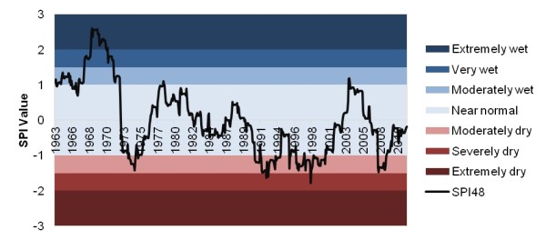
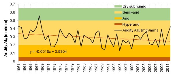
What is interesting is a possibly significant negative trend observed both in the SPI and aridity data. While on average conditions do not appear to be on the extreme side of dry or arid, the situation has taken a turn to more distressing figures during the recent decades.
Indirect causes
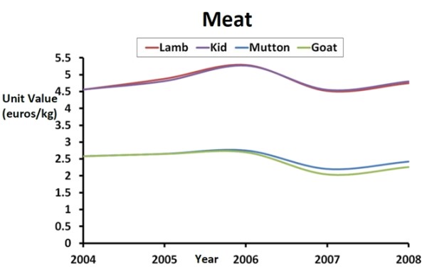
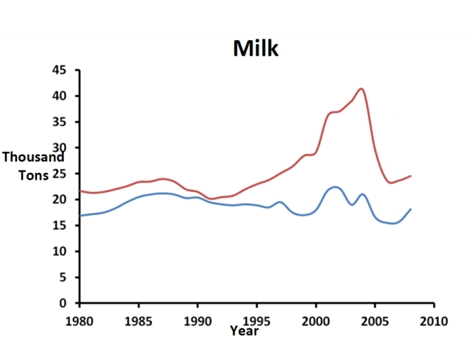
Sheep and goats play an important role in the economy of Cyprus in terms of meat and milk production. Although goats and sheep take up 18% of value animal production (including both meat and milk), they cover 90% of demand for goat and sheep products (both meat and milk) so that only 10% of relevant products is imported. Goat and sheep milk make up 22% of the total milk production in Cyprus, with the remaining 78% coming from cattle.
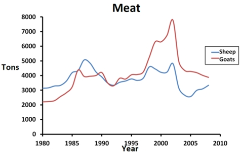
From 2000 to 2008, Cyprus faced a 34% decline in goat and sheep populations, due to the declining number of farming units, the aging farmer population and climate variability. The increase of protected areas in Cyprus has resulted in the relocation of the livestock around the Randi Forest area for grazing, increasing the amount of livestock in the area beyond that is permitted by the Government. As the Government does not strictly monitor the area, there is an over-abundance of goats and sheep for the area that resulted in the overgrazing that is evident in the study area.