| Authors: | Valdecantos, A. and Vallejo, V. R. |
| Coordinating authors: | Tsanis, I. K. and Daliakopoulos, I. N. |
| Editor: | Jane Brandt |
| Source document: | Daliakopoulos, I. and Tsanis, I. (eds) 2014. Historical evolution of dryland ecosystems. CASCADE Project Deliverable 2.1. CASCADE Report 04. 126 pp. |
Description of the study site
Location
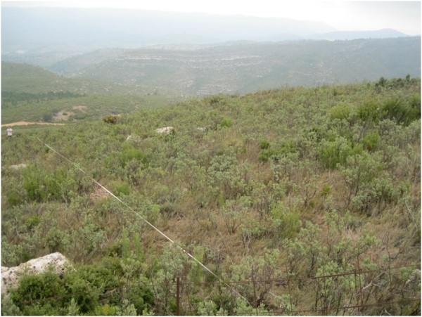
The Ayora Study Site is located in Eastern Spain within the Autonomous Community of Valencia (39º05 '- 40º5' N, 0º51' - 1º59' W). The Ayora Valley is on the border of the provinces of Albacete and Alicante, running between the Sierra Palomera and Mugrón mountain ranges to the west and Cortes de Pallás and the Caroig Peak. A multitude of forest tracks crossing the valleys and bordering the mountains shape the landscape of Ayora. The region is of inland Mediterranean landscapes and contains a rich variety of fauna and flora.
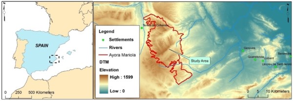
Topography
The Ayora Region covers an area of approximately 3,300 km². It is characterized by a diversified and rugged topography with moderate to steep slopes, partially covered with agricultural terraces that are currently abandoned and degraded. Altitude ranges from 20 m to nearly 1,200 m. The central part consists of an undulating area with an average elevation of about 600-700 m, interrupted by steep slopes and the valleys of the rivers Rio Grande and Escalona which drain the region in an easterly direction into the Jucar river and to the coastal plains. West of this central area, running straight from south to north, lies the Ayora-Cofrentes valley.
Geology and Soils
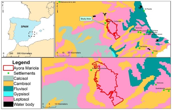
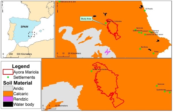
The dominant soil groups in the area are Regosols developed over marls and limestone colluviums. Secondary formations of shallow Leptosols and Luvisols, developed over limestone, can also be found. In the study area the dominant soils are Leptosols, with the exception of the north-west part where they give way to Cambisols. Calcaric soil material is dominant across the whole area.
Land Use
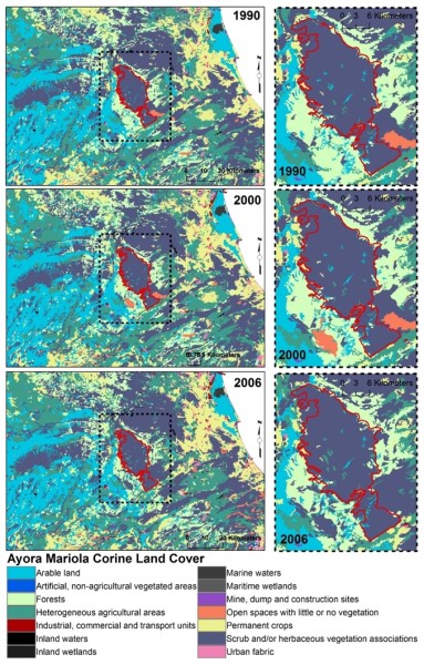
Over the last 30 years there have been significant changes in land use in Ayora and the region has been subject to widespread land abandonment. This has led to the encroachment of shrubs and accumulation of flammable biomass which has often served as fuel for wildfires and led to changes in the fire regime. Rangeland is the major land cover in the area, accounting for 67% of the study site. Besides these changes, land use appears to have been relatively stable since the 1990s.
Following a large fire event in 1979, a number of management interventions and mitigation schemes were introduced such as: afforestation efforts (P. halepensis, less frequently P. pinaster and Q. ilex); mechanical fuel load reduction and reduction of competition among plants; the creation of fire breaks; and the installation of water tanks. However, both remote sensing-based analysis and field inspection of these actions have rated them as mostly unsuccessful; wide areas were burned at least one more time after the 1979 fire event.
Climate
The climate in Ayora is typically Mediterranean, with hot, dry summers and mild winters. Specifically, the dominant climate type is dry Mesomediterranean with mean temperatures from 13 to 17 °C. The mean annual rainfall is between 350 and 700 mm and has a bimodal distribution with peaks in late autumn/early winter and in April/May. The distribution of precipitation differentiates two zones: a colder and drier northern zone (with 380-500 mm) and a southern zone with greater marine influence and milder temperatures and higher precipitation (500 -700 mm). Although rainfall occurs in all months the dry season, between July and August/September, limits the vegetative period to 8–11 months. Potential evapotranspiration reaches its yearly maximum during summer, causing a negative regional water balance, extremely low moisture content in the vegetation, and a very high risk of fire. Mean monthly precipitation, measured at the Ayora meteorological station, has a relatively stable long term average with mean annual precipitation of about 500 mm (or about 42 mm/month).
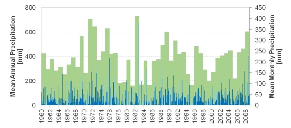
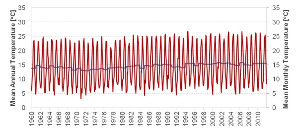
The temperature record shows only a slight upward trend and remains stable at an annual mean of 16.6 °C. The potential evaporation is estimated to be 1,325 mm.
Flora
Rangelands, accounting for 67% of the total land use, are largely dominated by dense shrublands and, to a lesser degree, by pine forests. These shrublands consist mainly of Quercus coccifera oaks with Ulex parviflorus and/or Rosmarinus officinalis. The pine forests are dominated by Pinus halepenensis and more rarely Pinus pinaster. Today, the typical Mediterranean woodland formations of Quercus ilex, P. pinaster and Pinus halepensis are only found in small remote and isolated areas. Agriculture is concentrated in the more suitable areas of the eastern plains and along the Ayora-Cofrentes valley. The mountainous areas, which were once under traditional, labour intensive cultivation, are now abandoned. This has led, particularly at the end of the 1960s and the beginning of the 1970s, to high fuel concentrations on once cultivated areas, enhancing the natural fire-prone environmental conditions of the region.
| Trees | |
| Unburned pine forests | Unburned pine forests have a continuous litter layer covering the whole soil surface, mainly composed of pine needles from groups of mature P. pinaster individuals. The understorey (0.5 – 1.5 m height) consists of resprouter shrub species such as Juniperus oxycedrus, Quercus coccifera, and Rhamnus alaternus, and a heavy grass layer (Brachypodium retusum). Other tree species, like Juniperus phoenicea and Quercus ilex, are probably propagated by jays, profiting from the presence of mature individuals scattered in cropland areas. |
| Regenerated pine forests | Regenerated pine forests can be found in areas where only one fire event has occurred. The regeneration of Pinus pinaster is, in general, low and located in north facing and less exposed slopes where the environmental conditions are more suitable for the establishment of this species. Pinus halepensis shows relatively higher regeneration success and therefore will likely be the dominant tree vegetation in the area in the near future, if no further disturbances occur. The density of the regeneration mostly depends on slope exposure, soil properties and the marine influence which promotes higher rainfall in the SE part of the burned area than in the central and NW ones. |
| Unburned holm oak forests | There is a Quercus ilex stand in the eastern part of the study site, and probably its core has not been affected by the 1979 fire. This patch is settled in the lowest part of the area (700 m) on decarbonated and deep soils developed over limestone and surrounded by old crop fields. |
| Shrublands | |
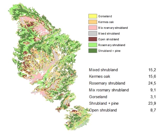
| Shrublands can be classified according to the presence and dominance of particular plant species, resulting in both mixed and pure shrublands. This probably reflects land uses, soil properties and disturbance regimes (mainly fires). | |
| Kermes oak shrublands | Kermes oak shrublands (Quercus coccifera) usually occur on red and brown fersiallitic soils developed from limestone and dolomite, probably because these soils were never cultivated. This vegetation forms continuous and dense shrublands dominated by resprouter species, especially Quercus coccifera and isolated individuals of tree species (Quercus ilex and Q. faginea). The development stage of this community depends on the fire frequency. |
| Gorse shrublands | Gorse shrublands (Ulex parviflorus) has a high presence in set-aside agricultural lands on soft substrates (marls). Obligate seeders are the dominant species, with a low presence of resprouter shrubs. Mediterranean shrublands accumulate significant amounts of dead standing biomass over time, thus increasing wildfire risk. Some plots within the study area show such heavy fuel accumulation because, at an age of 24 years, the stand has reached its senescence stage. |
| Mixed shrublands | In areas burned twice (i.e. 1979 and 1991, a total surface of ca. 4,800 ha) communities are found without a clear dominating species. The vegetation is composed both by resprouter (Q. coccifera, Juniperus oxycedrus, Rhamnus alaternus, Erica multiflora) and obligate seeder (U. parviflorus, Cistus spp, Rosmarinus officinalis) species, varying in relative proportions. The resprouter shrubs are distributed in small patches leaving open spaces between them that are occupied by seeder shrubs. The area is characterized by alternating limestone, dolomitic and marly soils. One of the most abundant plant species is kermes oak (Quercus coccifera) but it is substituted for heath (Erica multiflora) on marly soils. |
| Cistus spp. shrublands | The areas dominated by Mediterranean gorse, when burned again (in 1991 or 1996) usually generate shrublands dominated by Cistus spp. (especially C. albidus). This community is sparser than others and the presence of resprouter shrub species is almost non-existent, although the vegetal cover due to resprouter grasses (mainly Brachypodium retusum) is high. |
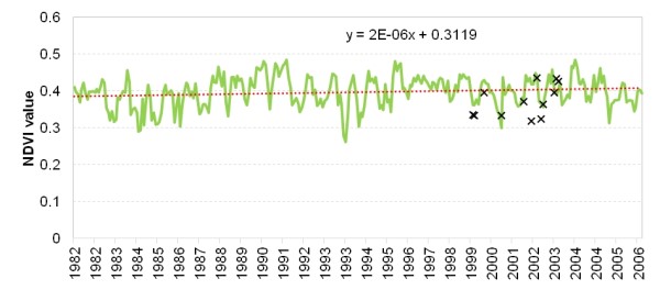
A synoptic view of vegetation health and the associated function of ecosystems can be derived from analysis of archival and on-going sequences of NDVI which shows a slight upward trend since the 1980s.
Selected vegetation – soil system
Forest and agriculture represent the main land uses in the study sites. During the 20th century many cultivated areas were abandoned and recolonized by early secondary successional species or, frequently, planted with pines. Colonization by later successional species (e.g. Quercus spp) used to be rather slow and always dependent on the presence of nearby preserved natural ecosystems and animals that disperse the seeds. As a consequence, a common landscape in the mid- and long- term in these former agricultural lands is a pine forest with a well-developed understory where seeder species are dominant. These communities are characterized by a large accumulation and density of standing biomass and consequently high fire risk.
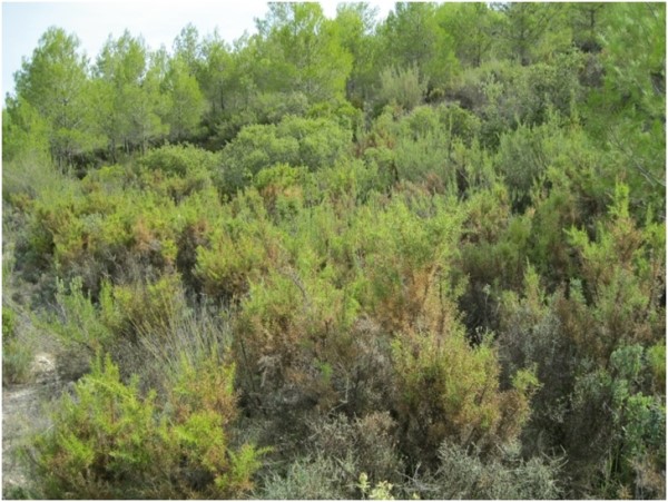
Wildfires are the main degradation driver in the Ayora study site. There was an exponential increase from the 1960s to the 1980s both in the number of fires and the burned surface. Therefore, the landscape is a mosaic of pine forests and shrublands that differ in their composition and structure. The tree layer, when present, consists of Pinus halepensis (Aleppo pine) and P. pinaster (maritime pine) either in pure or mixed stands. Seeder species dominate the shrub layer, the main species being Rosmarinus officinalis (rosemary), Ulex parviflorus (gorse) and Cistus albidus (rockrose). Resprouters like Quercus coccifera (kermes oak) are also present within the shrubland but in lower proportion than seeders.
Leptosols, stony and shallow soils formed on limestone and dolomite, dominate in the uplands while Regosols, less stony and deeper soils formed on marl, dominate the lower colluvial areas.
Socioeconomic status
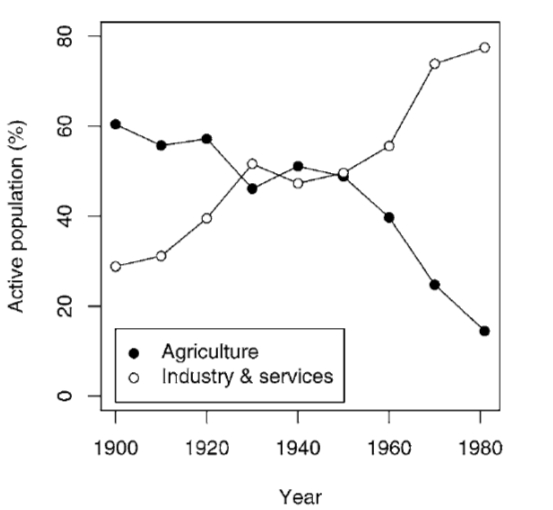
The small amount of economic activity taking place in the area is mostly associated with livestock. Before the 1979 wildfire, animals grazed the rangeland. Afterwards, as forest gave way to dense shrublands, sheep were mostly confined to croplands that were easier to navigate. In limited cases, administrative subsidies allowed grazing in firebreaks in order to assist in their maintenance. In contrast, goats are able to feed in shrublands but the number of animals is much lower than that of sheep (ca 3,000 vs 12,000). Additionally, beekeeping is an important economic activity in the region. The 1979 wildfire also resulted in a reduction of the logging exploitation of the forest from 24,000 to 2,000 m3 of wood per year. At present, more than 19,000 ha are cultivated in the Ayora valley, mainly cereals and olive, fruit and almond groves. This represents 17% of the total surface area of the region. The population employed in agriculture decreased from 20 to 5.6% in 15 years.
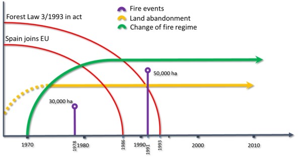
Timeline of events
The most relevant events in Ayora are two fire incidents in 1979 and 1991 which burned approximately 30,000 and 50,000 ha respectively. The land tenure status changed significantly, especially after the 1979 fire. Of lesser importance is the introduction of the Common Agricultural Policy (CAP) in Spain with its entrance in the EU in 1986.
Main Causes of Land Degradation
Human induced drivers
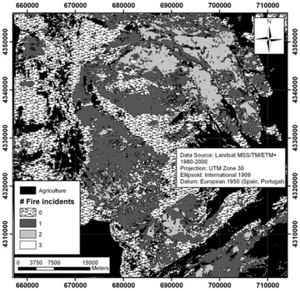
Forest fires constitute the main disturbance regime in the Ayora Study Site and have had strong effects on the landscape configuration. In the period 1975-2000 several wildfires took place in the area. Of these, the 1979 wildfire was the biggest and most devastating one. As a consequence, within the study site we may find different fire recurrences in such a small period of time. These forest fires have altered the composition of the forest, which prior to 1979 was dominated by Pinus halepensis, Pinus pinaster and, to a minor extent, Quercus ilex. At present, shrubland and regenerating pine (represented mainly by Pinus halepensis) occupy most of the surface; there are only small and isolated surfaces with the normal characteristic wooded vegetation of the area (Quercus ilex, Pinus pinaster and Pinus halepensis).
The recent increase in fire incidences, combined with the loss of ecosystem resilience due to past agricultural use and grazing, has driven a change in the composition of vegetation communities, from woodland and shrubland dominated by resprouting species to shrubland dominated by seeding species. When these shrublands are burned, further changes in plant species composition may occur, with the transition process influenced by fire recurrence. Thus, in the study site, fire recurrence is considered to drive important shifts in plant communities (from woodland to shrubland, from shrubland to open herb-sedgeland), and associated ecosystem functioning such as reduced post-fire regeneration rates leading to higher soil erosion risk. Therefore, short-interval fire cycles drive positive feedbacks that result in ecosystem degradation. Under these circumstances, the disappearance of key species, such as pines (due to repeated fires before producing viable seeds) and oaks (charcoaling and change of land use for cropping), represents a change in the ecosystem that needs external inputs through restoration to be reversed.
Natural Drivers
Climatic data show a general trend towards decreasing precipitation and increasing aridity in inland areas of the region of Valencia. In addition it has been suggested that there is a significant increase in the seasonal concentration of rainfall. These trends have had consequences for the fire regime; the main degradation driver of the region. A shift in the fire regime around the early 1970s has been reported, and researchers have suggested that while fire was not related to climatic conditions before 1970, since then it has been strongly driven by droughts.
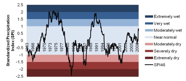
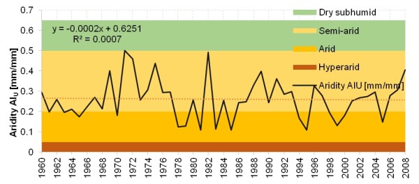
Temporal analysis of drought periods carried out in different weather stations in the area does not show clear conclusions. The Standardized Precipitation Index for the period 1950-2000 shows negative (drought increases over time), positive (drought decreases) and neutral trends. The long-period drought assessment that was carried out for the study area for the period 1960-2007 shows one period of extreme drought (around 1980) and two moderate to severe periods (around 1986 and 2001). Prolonged drought periods have not been seen in recent years and the SPI moves mostly in the area of normal climate. The Aridity Index shows the area to have a semi-arid character over the period 1960-2008, although values vary substantially between years.
Indirect causes
Growth of cities (offsite urbanization) has resulted in the abandonment of fields and therefore an uncontrolled growth of forests and shrubland. As a consequence, fuel accumulated and increased its continuity and, hence, the risk of fire occurrence, intensity and extension. A high agricultural population density led to over-exploitation and land-use transitions before the 50s until the rural depopulation of the 80s. The present low population density has lead to a lack of sufficient management and this in turn to higher fire risk due to uncontrolled growth of forests and shrubland.
Today labour is again available in the area but people (especially from the cities) are less aware of the risk of fire as their livelihood depends less on forest health and products. The urban population tends to visit villages and their surrounding natural areas mostly for recreation. This may be particularly dangerous in summertime when the population of rural areas increases significantly, vegetation is very dry and any negligence or malpractice can cause a terrible fire. Current consumption patterns have changed; the high demand for regional agricultural and forest products has been abandoned. Today the area is undergrazed and grazing is not profitable anymore. Both these factors have resulted in changes of vegetation composition.
Today land in the region is both publicly and privately owned. The government (local or regional administrations) is in charge of managing public land and this is only possible when there is available budget. Lack of resources can also lead to lack of good management, thus increasing the fire risk. Before the great wildfire of 1979, good infrastructures to fight against the fire were lacking. Afterwards, new plans for fire prevention and fighting were designed and implemented to some extent. Additionally, Forest Law 3/1993 induced the implementation of conservation interventions leading to more and better managed conservation practices such as afforestation efforts, and therefore lower fire risk. Unfortunately, the current economic crisis in Spain leads to a lack of investment in forest management thus exposing Ayora to wildfires once again.