| Authors: | Bautista, S. and Guixot, L. |
| Coordinating authors: | Tsanis, I. K. and Daliakopoulos, I. N. |
| Editor: | Jane Brandt |
| Source document: | Daliakopoulos, I. and Tsanis, I. (eds) 2014. Historical evolution of dryland ecosystems. CASCADE Project Deliverable 2.1. CASCADE Report 04. 126 pp. |
Description of the study site
Location
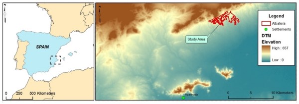
The Albatera Study Site is located on the Albatera-Crevillente range, within Albatera municipality, in Alicante province, Southeast Spain. An agricultural plain, part of the Segura river valley, lies south of the range and includes the town of Albatera, with a population of almost 12,000 inhabitants. Albatera municipality has mostly remained rural, although a variety of industries (such as textile, construction and mining) are also important in the area. The CASCADE Albatera experimental plots comprise a set of areas with natural vegetation (i.e. no croplands) on the southern area of the range.
Topography
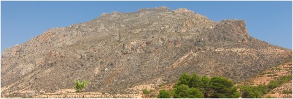
The Albatera-Crevillente range is located within the easternmost extreme of the Subbetic zone of the Betic Cordilleras, which crosses the south of the Iberian Peninsula in a WSW-ENE direction. San Cayetano (816 m) is the highest peak in the range and Monte Alto (682 m) is the highest in the study site. Slopes are moderate, for 25% of the area slope angle is under 25%. Mountainous areas are fragmented by ravines (ramblas), formed perpendicular to the range, frequently along tectonic faults. The range is connected to the alluvial plain by a relatively narrow strip of an intermediate hilly area, where both hillslopes and ravines are deeply altered by crop terraces.
Geology and soils
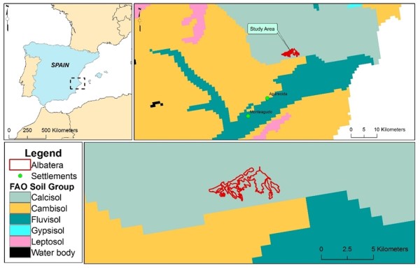
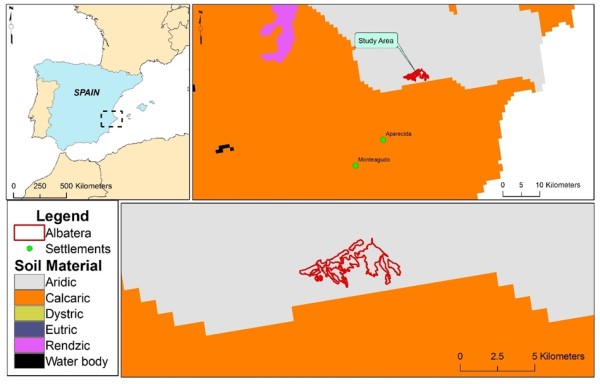
The range is formed by an anticline of Triassic, Jurassic and Cretaceous materials (gypsiferous loams of Keuper facies, limestones, dolomites, and dolomite limestones), whose WSW-ENE axis dips toward the east below a Miocene series. The Tertiary series begins, discordant, with levels of conglomerate and sandstones (molasses) and continues with loams, clays, marls, poorly-cemented sandstone, and ending with layers of conglomerate, sandstones and loams from the Pliocene. The compact calcareous nature of the core of Jurassic materials contrasts with the Tertiary materials, resulting in marked differential erosion that creates high mountain peaks bordered by deep ravines with vertical walls. According to the JRC WRB Soil Geographical Database, dominant soils in the mountain range area are Calcisols, while dominant soils in the alluvial plain south of the range are Cambisols and Fluvisols. According to the same source, aridic soils are dominant in the mountain range, while calcaric soils are dominant across the alluvial plain.
Land use
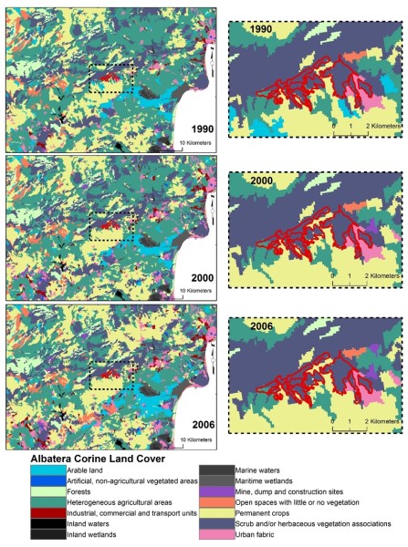
Albatera municipality has a surface area of 6,639 ha. The main land use is agriculture (52% of the land) with scrublands and woodlands covering 24% of the area. The rest of the land (21%) is distributed among a variety of land uses, including urbanisation and industries. Crops are one third lemon and orange trees, one third fruit-trees (such as pomegranates and figs) and one third a variety including olives, date palms and and vineyards. The study site, which is located on the mountain range area, is mostly covered by a mosaic of shrubland and degraded scrubland, with some patches of pine forests originating from various reforestation/afforestation activities implemented in the 1970s-80s. CORINE Land Cover data show no change in the between 1990 and 2006, indicating rather stable woodland-scrubland zones (despite the various reforestation activities in the area). The only significant change was the transformation of several patches of arable land into permanent crops after 1990.
Climate
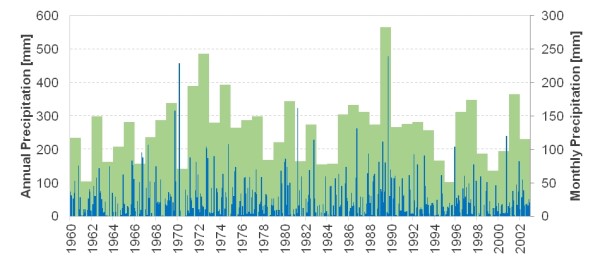
The climate is classified as (steppe) semiarid according to the Köppen climate classification, and as arid according to the UNEP Aridity Index (AI) adopted by the UNCCD. About 35% of the annual precipitation occurs in autumn, 30% in spring, 20% in winter and only around 15% during summer. The highest values of monthly precipitation are commonly recorded in October. According to the available record, annual precipitation shows no significant trend and remains stable at 267 mm.
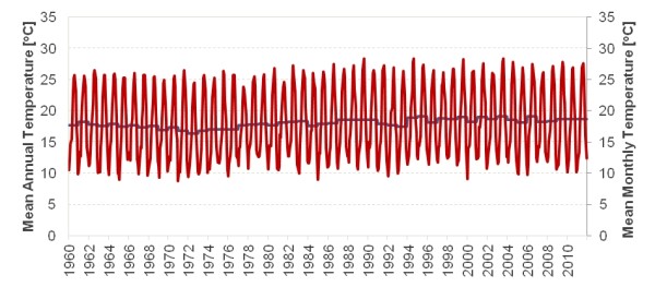
Again, according to the available record, temperature shows a slight upward trend with an annual mean of 18 oC. Potential evaporation is estimated at 1,633 mm.
Hydrogeology
There is no permanent-flow channel in the Albatera area. However, the overland flow produced on the mountain range slopes concentrates along a number of intermittent-flow channels (ramblas) that only carry water after major rainfall events. Close to their sources, the ramblas have a great erosive potential, creating a system of deep channels that connect the mountain range and the lowland. In the lowland, the ramblas become wider and shallower, and the channels are often altered by human activities. Finally, the channels disappear into the alluvial plain, where runoff becomes diffuse.
The Albatera area hosts parts of two aquifer systems: the Vega Baja and the Crevillente aquifers. Both aquifers provide water of relatively poor quality that is mostly used for irrigation. The Vega Baja is a large (750 km2) alluvial aquifer that lies on the south of the area (alluvial plain) and comprises the Quaternary sediments of the lower Segura river valley. The Crevillente aquifer (140 km2), is partly located within the Albatera Study Site. It is a karstic aquifer that comprises a series of Jurassic limestones and dolomites, more than 500 m thick, which forms the core and uppermost part of the Albatera-Crevillente range. The system lacks permanently flowing streams or springs. Aquifer recharge is from precipitation over outcrops of permeable rocks, and it has been estimated to range between 6 and 10 hm3 per year, with peaks up to 16 hm3 in very wet years.
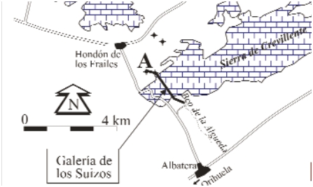
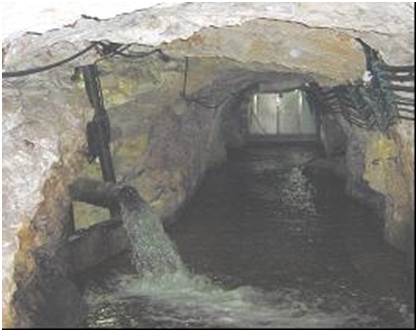
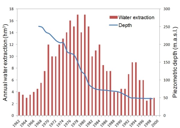
The southwestern area of Crevillente aquifer (located within the study area) is exploited through the water-mining system of Los Suizos Gallery. Inside the gallery, there are wells that pour the extracted water on the gallery floor. Water is driven over 2 km to the gallery mouth and distributed for irrigation from this point. Intense exploitation of the aquifer started in the early 1960s, with the construction of the gallery, and continued for several decades, resulting in an overall decrease in piezometric level of around 200 m, abandonment of boreholes, and severe deterioration of water quality. In 1987, the governmental water authority designated the aquifer as overexploited. Although water extraction has been reduced in recent years, it is still highly mineralized, of very poor quality, and several overexploited pockets can still be identified in the area. Today, of the original 12 extraction points drilled inside the gallery, only four pumps remain in use, the others having been abandoned. The current pumping capacity is 350 l/s and the water is mainly used to irrigate various areas within the boundaries of Albatera and neighbouring municipalities.
There are many artificial channels in the area for both inter-basin transfers and water redistribution. The Tajo-Segura inter-basin transfer is of particular interest, as it is an important source of water for both irrigation and domestic supply in the area. It crosses Albatera municipality from West to East, around 2 km south of the Albatera-Crevillente range.
Main ecosystems
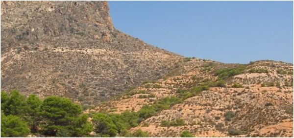
Thermo-Mediterranean shrublands. The natural climate-driven vegetation communities in Albatera are thermo-Mediterranean shrublands, dominated by deep-rooting tall shrub species that are particularly adapted to water scarcity and extreme summer drought conditions. In healthy shrublands, total plant cover is relatively high (> 60%), and consists of big patches of tall shrubs within a matrix of grasses, subshrubs, chamaephytes and bare soil. The most common tall-srub species in this type of communities are: Rhamnus lycioides, Quercus coccifera, Pistacia lentiscus, Olea europaea ssp sylvestris, Juniperus oxycedrus, Osyris quadripartita, Ephedra fragilis, Chamaerops humilis and Witania frutescens. Most of these are resprouting species that can regenerate from the root collar if burned or cut. Few patches of well-preserved tall-shrubland can be found in the area, mainly on high-altitude rocky areas, where rock outcrops and difficult access have prevented or decreased the (marginal) agricultural use of the land, and on relatively humid swales, where higher water availability has allowed a good development the plant communities.
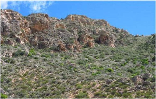
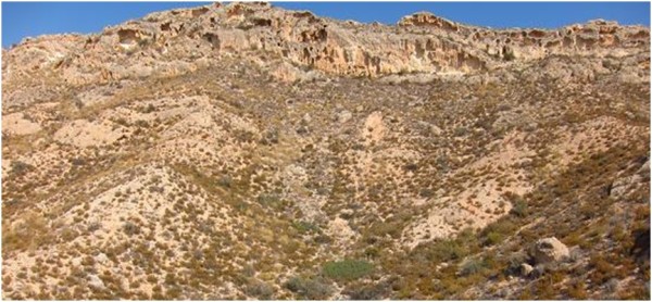
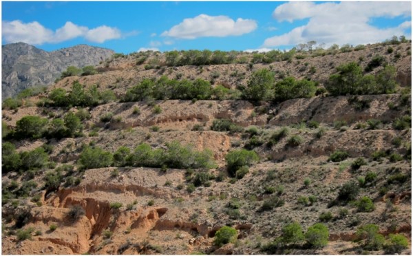
Degraded and reforested/afforested ecosystems. Intense land exploitation, which often included uprooting resprouting species, has led to changes in vegetation towards ecosystems dominated by subshrubs and tussock grasses, with very low plant cover (around 30%) on a matrix of degraded bare soil. Dominant species in these communities are subshrubs such as Globularia alypum, Rosmarinus offcinalis, Cistus clussi and Anthyllis citisoides; chamaephyte species such as Thymus vulgaris, Fumana ericoides and Helianthemum apenninun; perennial grasses such as Stipa tenacissima, Lygeum spartum and Brachypodium retusum. The area also includes a number of scattered Aleppo pine (Pinus halepensis) forest patches, which have resulted from past reforestation programs implemented in the area, mostly through terracing.
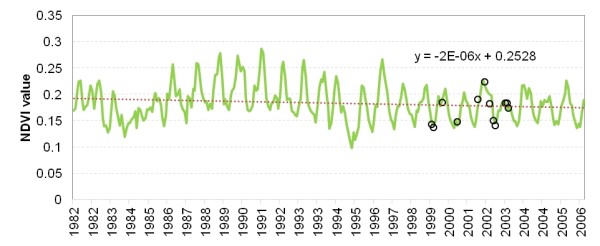
General recent dynamic of vegetation health. A synoptic view of vegetation health and the associated function of ecosystems can be derived from analysis of archival and on-going sequences of NDVI which shows a slightly decreasing trend since the 1980s and a reduction of the osculation width. Taking into account the relative stability of precipitation, this change could be interpreted as a sign of reduced vegetation productivity, possibly due to land degradation.
Selected ecosystems for CASCADE assessment. Four types of ecosystems or landscape units, representing different levels of degradation, have been selected for the assessment of degradation and restoration impacts on ecosystem services provision in the Albatera Study Site: (a) Healthy (remnant) Mediterranean shrublands; (b) Degraded dwarf shrublands; (c) Old pine reforestation on terraces implemented on 1970s-80s; and (d) Restored shrublands (multispecies plantation; 2004-06).
Socioeconomic status
Before the 1950s, the economy of Albatera municipality fully relied on agriculture, originally based on both irrigated farming, in the low lands of the Segura river basin, and rainfed crops, mainly on terraces of the lowest parts of the mountain range and on the transition areas between the range and the low lands. During this period, the mountain range also supported some marginal activities such as alpha-grass harvesting (for fibre production) and firewood gathering. Grazing was moderately important before the 1950s; for example, in 1910, the livestock census for Albatera was around 1,000 animals (evenly distributed among sheep, goats, pigs, mules, horses and donkeys) a number which is considered to be the total livestock capacity for the area. At that time, Albatera had a population of 4,050 inhabitants.
The trade of pigs was important in the 19th and first half of 20th century, but there was no other important commercial or industrial activity. Average family farm income was low, a fact that led to several migration pulses, mostly during 1900-1925 and in the 1950s.
During the second half of the 20th century, major socio-economic changes resulting from the widespread use of fossil-fuel derived products, industrial development and intensification of tourism, led to general rural land abandonment in Spain. In Albatera, agriculture abandonment mostly affected rainfed crops and agricultural terraces located on (or near to) the mountain range. Grazing, wood gathering, alpha-grass harvesting and other marginal activities also ceased. Despite this process of land abandonment, the economy of Albatera continues to mainly rely on irrigation farming (mainly lemon and orange trees and other fruit-tree crops such as pomegranates and figs) located on the low lands and transition areas between the low lands and the mountain range. However, the fragmentation of agricultural land, the spread of second-home urbanisations, and the aging of the farmer population (and associated increase in part-time agriculture) are processes that challenge the future of agriculture in Albatera. Textile and building-sector industries, commerce and an incipient tourism industry are recently gaining economic importance and have contributed to a significant population increase in recent years (from 8,811 inhabitants in 2000 to 11,936 inhabitants in 2012).
Since the late 19th century, the mountain range area has been a public domain, belonging to the municipality of Albatera but being jointly managed by the Forest Service of the Valencia Regional Government and the municipality. The Albatera Study Site is located on “forest land”, the main land use in the mountain range. No farming activity is currently allowed in the area. At present, the exploitation of natural resources is limited to small-game hunting (rabbits, partridges) and snail harvesting, although limited grazing can sporadically take place.
In 2002, the association of irrigation-land owners signed a 99 year concession agreement for the exploitation of Los Suizos Gallery, which includes the right for improvement, maintenance and repair work on the gallery and associated distribution channels.
Timeline of events
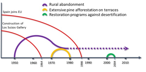
The most important recent changes and milestones that have occurred since the 1950s in the natural and social environment of Albatera and that are relevant for understanding current land condition are included in the figure below. Prior to those events, two more periods can be considered important:
- 1900-1920s: several migration pulses, triggered by the low profitability of agricultural land; associated abandonment of marginal agricultural and grazing on the Albatera-Crevillente range slopes.
- 1920s-30s: sharp increase in irrigation land, with associated decrease in migration rate.
Main causes of land degradation
Human induced drivers
As in most dryland areas of the Mediterranean Basin, the long-term impact of intense land use, including burning, woodland clearing, grazing, terracing and cultivation, has resulted in strongly human-modified landscapes in the Albatera area, and the relative role played by each of those old disturbances is difficult to unravel. In more recent times, two main periods, with contrasting socio-economic conditions, are of major relevance as drivers of the current land condition in the area:
- Before the 1950s, the economy of the area completely relied on agriculture. Agricultural activities were originally based on irrigated farming, mainly from the Segura river waters and rainfed crops on the lowest parts of the mountain range. Later, a switch towards fully irrigated farming took place, resulting from access to additional sources of water such as inter-basin transfers and construction of new irrigation systems. During this period, the Albatera mountain range area was exploited through a diffuse set of marginal activities including marginal agriculture, grazing, wood gathering and alpha-grass (Stipa tenacissima) exploitation for fibre production. The accumulated impact of these activities heavily altered the natural shrublands (though still some remnant patches can be found) and promoted land degradation. The main consequences of this degradation include: loss of ecosystem functions (water infiltration and nutrient cycling), reduced productivity; very low plant cover; and net loss of resources (water, soil) from the system. In addition, off-site damage due to flooding is also important. According to the Land Action Plan to Prevent Flooding in the Valencia Region (PATRICOVA, Regional Government), the Albatera-Crevillente range is one of the hot spots of flooding risk in the province of Alicante.
- During the second half of the 20th century, major socio-economic changes occurred in Spain that led to a generalized trend of rural land abandonment. Most of the agricultural land in Albatera is family-owned, with an average property size of 1.8 ha and relatively low productivity value. This has fostered rural land abandonment and the development of commercial and industrial activities. Nowadays, further fragmentation of agricultural land is taking place in response of demands for other land uses (e.g. second-home urbanisations and part-time agriculture). Resource exploitation in the mountain range area has mostly ceased, with the exception of some terraced crop enclaves in the lowest parts of the range and the water-mining system of Los Suizos gallery. Grazing is almost absent.
Several afforestation/reforestation programmes have taken place in this period. These actions, mainly aimed at controlling erosion and floods, have yielded poor results. Unsuccessful reforestation through terracing and maintenance works on the pipe system for water distribution from the Los Suizos Gallery have further altered and degraded the landscape. In recent years, a new set of restoration actions have been implemented in the site by the Valencia Region Forest Service and the Spanish Ministry of Environment. These actions mainly consist of multi-species and spatially heterogeneous plantations designed to combat the multifaceted land degradation of the area. The selection of plant species focused on matching the diversity of habitats, landscape functional units, and natural patterns in the target area.
Natural drivers
Both prolonged droughts and wet periods are common in the area, reflecting the well-known inter-annual heterogeneity in precipitation of arid and semiarid lands. However, dry periods were more frequent than wet periods. Severe long droughts took place during 1963-65, 1983-85, and 1994-96. Mild drought conditions were also observed during 2000-02. It should not go unnoticed that the severe droughts of 1983-85 and 1994-96 coincide well with two instances of extreme NDVI decline. Given the low resolution of the NDVI analysis at this point, the spatial extent and gravity of the effect of those droughts appears substantial.
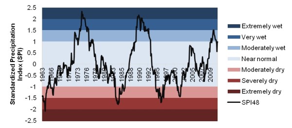
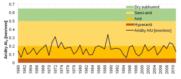
Regarding the aridity index, the area displays stability within the arid bracket with few years that crossed over to a semi-arid character, and two years (1962 and 1995) that approached hyper-arid conditions. Although less evident, 1983-85 and 1994-96 also appear to be important milestones for the fate of the local climate and ecosystem.