Research challenge
One of the most challenging themes in ecology to date has been to understand discontinuous changes or sudden shifts in ecosystems. Recognition and documentation of sudden changes in ecosystem structure and function have become a major research focus during the past 10 to 20 years. Discontinuous changes have been observed and analysed for a wide variety of ecological systems, including lakes, peatlands, marine systems, forests and also drylands and rangelands. As an example, an increase in grazing may seem to lead to only a marginal decrease in vegetation cover, until a critical threshold is passed (also termed ‘tipping-point’). At this point the ecosystem shifts to an alternative stable state, characterized by a different structure, species composition and/or functioning, which may, for example, no longer be able to provide sufficient food for herbivores. Thus, the relationship between increasing pressure and observed ecosystem state (e.g. vegetation cover) is described as non- linear or discontinuous. This phenomenon qualifies as a “catastrophic shift” (according to the mathematician René Thom’s catastrophe theory), an abrupt change in the state of a system that is difficult or impossible to revert. One of the reasons a system can undergo a regime shift is because the external pressure grows beyond a threshold point. This is normally caused by a change in processes at larger scale (e.g. climate change induces an increase in fire frequency and intensity), but can be intensified through a cascading series of events (e.g. the drought degrades the soil, reducing its water holding capacity, which in turn increases the impacts of the drought). If thresholds or tipping points are passed, the ecosystem may change state, either positively or negatively, and sometimes irreversibly (in terms of species composition and relative abundances, species richness, and total vegetation cover), as illustrated in Figure 3A. Sudden transitions have been shown to occur under continuous external stress, such as decreased water availability or increased grazing. When an external pressure is an event that occurs at discrete points in time such as wildfires, sudden shifts can be anticipated and thresholds relevant to event frequency and intensity are possible key indicators.
Transitions to a degraded state can, in drylands, cause a profound change in the provision of ecosystem services and can lead to desertification, thereby greatly reducing human benefit, affecting livelihoods and possibly inducing land abandonment. Critical thresholds, at which dryland ecosystems degrade from a desired to an undesired state, with bare ground or undesired plant composition, imply major losses of biological diversity, ecosystem functioning and resilience. Regime shifts are difficult to predict: even if a system has remained stable for a long period, a regime shift can occur abruptly and with very limited warning signals. However, certain features of spatial vegetation patterns may provide indicators of the proximity to thresholds in dryland areas. In particular, in dryland areas vegetation often occurs in patches separated by bare soil (inter-patch) and the pattern of these patches changes when a threshold is approaching. Hence, the use of such indicators is a first approach to predict occurrence of shifts. A second approach consists of looking at the occurrence and strength of the environmental drivers that may push an ecosystem from a healthy to a degraded state. Kéfi et al. (2007) showed, both empirically and by modelling, that grazing intensity and/or resource availability may force a system towards such a catastrophic shift so that the levels of strengths of these drivers can serve as indicators of where the shifts are likely to occur. Also modelling studies by other researchers of shallow lakes have successfully adopted this driver approach, identifying critical levels of phosphate loading for ecosystem shifts. The third and most recent approach to better understand and predict shifts in ecosystem states involves a system approach. This approach takes into account as many ecosystem properties as possible, as well as the interplay between these properties.
Recovery of a degraded ecosystem into a previous healthy state is usually difficult if not impossible: once the system has shifted to a new configuration (called "degraded stable state"), return to the stable healthy state tends to display hysteresis (see figure 3A), meaning that the path to degradation differs from the path to recovery. Thus, it is not sufficient to reduce the pressure on the system for the ecosystem to return to the healthy situation, since necessary resources to return to that state could have been lost.
The challenge is to understand the thresholds that may lead to shifts more clearly, to provide early warning of impending issues, so that strategies can be put in place to use environmental resources more sustainably. In the era of the 2030 Sustainable Development Goals (SDGs), which encompass ideas around Land Degradation Neutrality (LDN), advancing this understanding becomes even more critical. It is very important for global sustainability to understand how drylands respond to ongoing environmental change, as drylands form a significant part of the Earth’s surface. Better identification of early warning signals for such changes can help us to develop better-timed and more cost-effective solutions, allowing anticipation of, adaptation to, or even prevention of, undesirable ecosystem shifts (Sietz el al, 2017). Both continuous and discontinuous transitions result especially from human activities and changing climate, and may be prevented by proper management. Therefore, management decisions at individual, institutional and policy levels are critical to prevent the downward spiral of degradation and desertification.
The CASCADE (Catastrophic shifts in drylands: how can we prevent ecosystem degradation?) Project has taken an ambitious approach to examining critical thresholds in European dryland landscapes. CASCADE was financed by the European Commission and consisted of a multi-disciplinary team from 15 institutes contributing expertise in: plant ecology at a range of spatial scales; soil science; modelling grazing, fire and land abandonment; economy; land management in drylands; and the formulation of effective policies to promote sustainable land use and LDN. One of the main objectives of CASCADE was to assess whether there are losses of important environmental ecosystem services resulting from the pressures on ecosystems, and from associated sudden shifts, and to quantify these losses if they occur. Knowing and understanding the structure, function and provision of services of degraded and reference (not necessarily pristine) ecosystems at present is a very useful tool to define restoration and conservation management practices. As vegetation patterns are considered one of the main indicators for imminent shifts in drylands, CASCADE focused on those ecosystems in which vegetation patterns can be expected, namely grasslands, shrublands and forests. Within these systems, research was conducted on a range of scales, from detailed studies of plant and soil characteristics at patch scale and plant – soil interactions, to modelling management options at regional level. Finally, practical management guidelines were erected to prevent tipping points from occurring, and also socio- economic consequences and optimal timing opportunities was investigated.
Since current understanding about the causes and characteristics of catastrophic ecosystem shifts in Mediterranean drylands is limited, the CASCADE Project addressed the following three key research questions within the context of Mediterranean drylands :
- Q1 What are sudden ecosystem shifts?
- Q2 What processes happen in the soil and plants during a shift?
- Q3 How can we manage vulnerable ecosystems better?
By answering these questions in this section of CASCADiS we also provide a synthesis of the CASCADE project.
Methodology
The methodology used in CASCADE to answer the 3 research questions Q1-Q3 is summarized in Figure 2. The first step was to select reference ecosystems within the 6 study sites. Within these ecosystems, drivers (Tsanis and Daliakopoulos, 2014) and stress levels were identified, and it was determined who were the stakeholders and which were the relevant policies. Regarding stress levels, 4 levels were identified as shown in Figure 2.
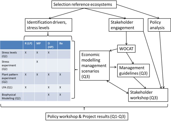
Figure 2
Different kinds of experiments were used to research these different levels; each using its own methods and each focusing on one or more of the research questions:
- Stress levels were investigated by monitoring soil and plant characteristics (Mayor, 2015, 2017). The CASCADE project assessed soil improvement as a function of a stress gradient, aiming to identify functional thresholds and processes that might occur after a critical decrease in the soil-in plant system. The CASCADE project carried out various experiments to identify soil- and plant-mediated signals of (imminent) ecosystem shifts soil at patch scale during a shift. In the first, so-called ‘stress- gradient’ experiment, we compared soil quality and performance of targeted plant species at three levels of stress as they occurred under field conditions. In this observational approach we measured soil properties within plant patches and outside plant patches (inter-patches), measuring canopy cover, basal diameter, soil organic carbon and other plant and soil characteristics (Mayor 2015).
- Following the stress level investigation, a stress experiment was conducted in which roofs were used for different duration to mimic the effect of drought (Mayor, 2017). In this so-called ‘drought-stress’ experiment, we again performed the same set of soil and plant measurements, but now comparing different manipulative treatments at a the MP stress level. This level was chosen because the HP level is already degraded (past the tipping point), while for the LP level it is unlikely that shifts can be reached by manipulating the system. By means of translucent roofs, we excluded rainfall from the vegetation patch to enhance drought conditions. As control, we used roofs that let the rain fall through as well as vegetation patches without roofs.
- Manipulative plant pattern experiments where conducted to study effect of vegetation pattern on resource loss, and on restoration potential (Bautista et al, 2015, 2017). The effect of plant cover and pattern on resource conservation was studied on experimental plots and natural slopes. Degradation reversal potential was assessed as a function of plant colonization pattern and diversity and the hypothesized eco-hydrological feedbacks that modulate dryland dynamics. At the patch scale, we compared the performance of (1) multispecies versus monospecific patches, and (2) patches with singe individuals versus patches with increasing number of individuals and or species.
- Landscape and Function Analysis (LFA) was used to study ecosystem services provided by systems at different levels of degradation (Valdecantos and Vallejo, 2015). CASCADE studied the key properties of the ecosystems (and derived services) and assessed the degree to which they have been affected by the degradation drivers. The three aspects of the evaluation process carried out were: 1) determination of plant composition of the ecosystem, 2) quantification of standing plant biomass, litter and belowground biomass, and 3) application of the methodology of LFA that combines spatial distribution of vegetation and the assessment of soil surface properties. The selection of these key common indicators and assessment methods has been based on the work developed by the EU-funded PRACTICE project (Bautista and Mayor, 2010). They represent few essential indicators that can characterize ecosystem functioning for a majority of drylands worldwide, mostly focusing on five ecosystem services: water and soil conservation, nutrient cycling, carbon sequestration, and diversity of vascular plants. Most provisioning and cultural services are considered to be very much context dependent. Therefore, our across-site comparative assessment of ecosystem services provision has been only based on supporting-regulating services, which together with biodiversity, are considered to be baseline services and properties that underpin other types of services (Bautista and Lamb, 2013). The methodology has been applied in all CASCADE field sites in at least two ecosystems representative of a healthy reference and a degraded state, and where available also in a restored site (Table 1).
- Bio-physical modelling was done to understand and predict sudden shifts (Kefi et al, 2016). Models focused on two axes of improvement of current dryland models relevant to study dryland resilience: i) the way external pressures are incorporated in dryland models; we focused on three types of external pressures: grazing, fire and drought; ii) the way vegetation (the ‘biotic component’) is modelled; we incorporated species, functional groups and species- species interactions in dryland vegetation models. We investigated how the additional ecological mechanisms included affected the response of the ecosystem to stress. We especially looked for shift behaviours and identified the conditions that favoured the emergence of catastrophic shifts at the ecosystem scale.
- Stakeholders were engaged at the beginning of the project, and perceived current and future changes in environmental conditions and adaptations to those conditions were explored through stakeholder focus groups early on in the project. The existing land management practices were subsequently assessed using the standard WOCAT technology questionnaire (WOCAT, 2008) with stakeholder involvement. Those results formed the basis of an in-depth study on sustainability and resilience of land management practices vis-à-vis ecosystem thresholds and disturbances (Jucker et al, under review).
Results of experiments and well as the WOCAT questionnaires were used to model the economic effects of different management scenarios (De Ita et al, 2017), following the rationale described in Sietz et al (2017). Further, we evaluated the socio-ecological effectiveness of land management by linking non-linear ecosystem behaviour to an economic evaluation of land management options providing essential insights into appropriate timings, climate-induced windows of opportunity and risk and financial viability of investments (Sietz et al., 2017). These considerations informed an integrated modelling assessment in which the effects of a set of management scenarios were evaluated regarding their ecological impact, i.e. the likelihood that vegetation cover remains above a critical threshold, as well as their economic impact, i.e. net present value over a period of 10 years. Stakeholder engagement formed a fundamental part of our integrated assessment. Future changes and expectations expressed by stakeholders make management scenarios more realistic and coherent with their willingness to act. Economic modelling results, WOCAT information and information on relevant policies were combined to formulate management guidelines, which were discussed with stakeholders in workshops held in each of the 6 study sites. Key questions on the role of land management practices during extreme events were assessed together with stakeholders. Feedback from stakeholders was used to fine-tune the scenarios. Finally, project results were presented to, and discussed with, policy stakeholders from all sites in a ‘policy workshop’.