| Authors: | Tsanis, I. K. and Daliakopoulos, I. N. |
| Editor: | Jane Brandt |
| Source document: | Daliakopoulos, I. and Tsanis, I. (eds) 2014. Drivers of change in the study sites. CASCADE Project Deliverable 2.2. CASCADE Report 06. 59 pp. |
Historical Climate
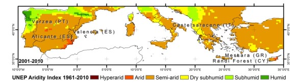
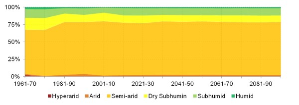
In terms of recent climate change, most stable European Mediterranean drylands are located in South and East Spain (ES6 & ES5), Insular Italy (ITG), the Aegean Islands and Crete (GR4) and Cyprus (CY0). Regarding the CASCADE Study Sites for the period 1961-2010, Alicante has been Arid, Valencia, Messara and Randi Forest have been stably Semi-arid, Castelsaraceno has been Dry subhumid and Varzea Subhumid.
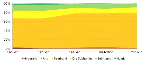
Overall, the CASCADE Study Sites are arid to some degree, with Alicante representing the lowest and Varzea the highest part of the aridity gradient. From the 50 year record, it is unclear whether permanent aridity regime shifts are taking place in the European Mediterranean drylands. Nevertheless, the entire domain under consideration has been undergoing an overall increase in the percent of arid area by almost 15% (from 64% to 78%) in dispense of more humid aridity classes, while arid area has remained more or less stable.
Observing the trend of aridity over the Mediterranean in decadal terms, Varzea has been getting steadily drier, gradually crossing from Humid to Subhumid and Dry-subhumid. This trend can also be observed for the entire northeast Atlantic Ocean coastline within the investigated domain, along the Cantabrian Mountains. A similar aridification can be observed along the axis of the Pindus Mountain range in Greece and the Appennini Mountains in Italy during the past 50 years.
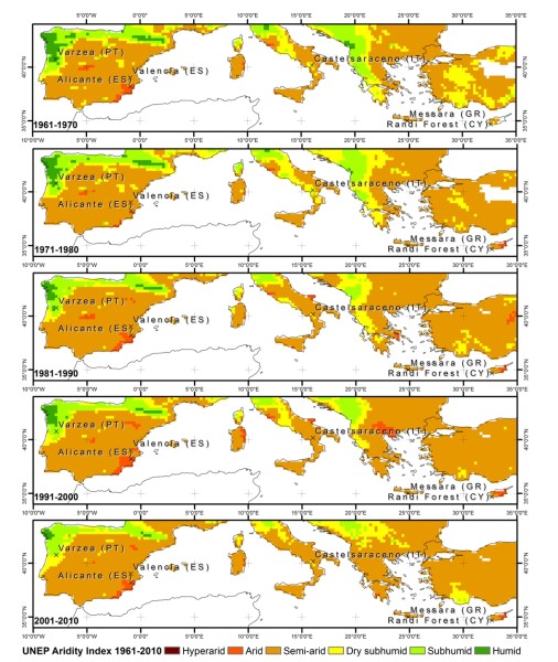
Comparing today (2010) with the past four decades, the 1960s have been one class less humid for Mainland Portugal (PT1) and Northern Spain (ES1, ES2) and at least two classes less humid for Central Greece (GR2). North West and Central Italy (ITC, ITE) also had some more humid decades during the same period. Alicante, located in one of the most persistently arid areas of the investigated domain, fluctuates between Arid and Semi-arid along with Central Italy (ITE), Cyprus and Crete. Focusing on the CASCADE Study Sites, results indicate that Várzea (representing Mainland Portugal – PT1) may be currently experiencing a regime shift from a predominantly humid area to subhumid or marginally dry-subhumid state. Castelsaraceno (South Italy – ITF) is fluctuating between Dry-subhumid and Semiarid states, whereas Alicante (South Spain – ES6) and Valencia (East Spain – ES5) are fluctuating between Arid and Semiarid states. Finally, Messara (located in Aegean Islands and Crete – GR4) and Randi Forest (Cyprus – CY0) have a stably Semi-arid status.
Future Climate
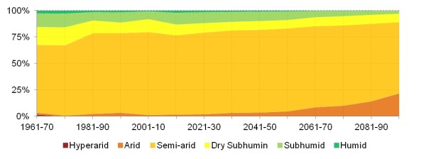
For ease of presentation and discussion, climate model results are averaged over the investigated domain for annual, decadal and 50-year time intervals. Here we do not consider uncertainties due to model averaging. Therefore the variability of future climate appears smaller than that of observations presented in the previous chapter. While this is an oversimplification it depicts well projected trends. According to RCP26, the picture of Aridity in Southern Europe does not change significantly. Aridity hotspots such as those in Spain, Italy and Cyprus remain more or less stable for the terms 2011 – 2050 and 2061 – 2100, relative to the reference period 1961 – 2010.This stability, with the semiarid areas remaining at an average of 76% of the total, can be seen after the abrupt 14% increase encountered during the reference period. The same applies for arid areas that steadily cover less than 2% of the examined domain.
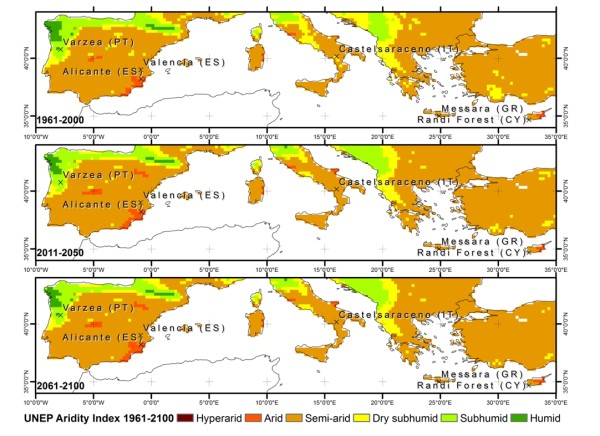
In contrast, RCP45 predicts that semi-arid and arid areas gradually increase to reach more than 77% by 2050 and 78% by the end of 2100. Semiarid areas over Italy and Greece gradually expand while arid zones in Spain and Cyprus take alarming extents. During the course of the century, the pathway projects a pronounced decrease of the humid zone from 3% in the 80s to 1% in 2100, affecting primarily the northeast Atlantic Ocean coastline. The cases of Várzea, Valencia and Castelsaraceno are very characteristic, with all of them steadily becoming one class more arid.
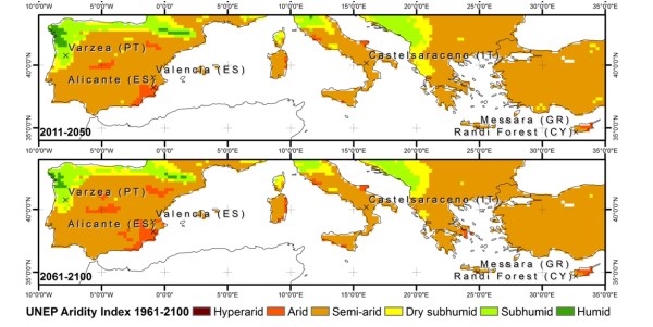
Finally, RCP85 presents the least optimistic realization with aridification reaching extremes, particularly over Spain, at the end of the century. Overall, Study Site areas that during the reference period belonged to a more humid zone (Várzea, Valencia and Castelsaraceno) appear to be more sensitive to change than those already arid (Alicante, Messara and Randi Forest). Humid zones become negligible by 2050, but more importantly, even subhumid zones cover less than 3% by the end of 2100. After 2050, arid zones gradually cover as much as a devastating 20% of Southern Europe.
Sensitivity of vegetation to climate
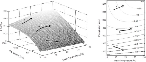
The expected change of the ETa/ETp ratio for a theoretical range of mean Temperature T of 10 to 30°C and annual precipitation R of 100 to 1500mm is illustrated in the figure below. The values of the Blaney-Criddle equation are estimated for latitude 32°. At first glance, low temperatures appear to limit the maximum achievable ETa/ETp ratio, which converges to lower values as precipitation increases. Also, for higher annual precipitation values (e.g. over 900mm), the expected temperature causes a sharp increase of ETa/ETp, at least up to a certain threshold depending on the respective precipitation value (vector a in the figure). Nevertheless, for moderate and lower annual precipitation values (e.g. under 700mm) the fraction of ETa/ETp decreases as mean temperature rises (vector c in the figure). A notable finding is that this system of equations clearly shows a transition from a moderately unstable to a highly unstable equilibrium as temperature rises. This is highlighted by the observation that for moderate R values (e.g. 500-700mm), a small change in precipitation can cause significantly larger changes in ETa/ETp as temperature increases (vector b in the figure).
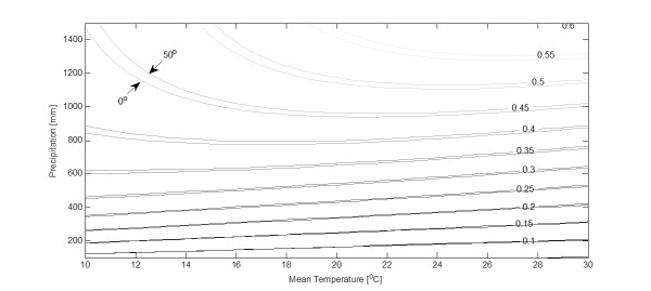
Regarding the effect of latitude on the model, the Blaney and Criddle equation predicts that a decrease of the mean daily percentage p of total daytime hours that takes place approaching the equator increases, the value of the ETa/ETp.The figure below depicts this change, also showing the limits that envelop the ratio ETa/ETp for latitudes 0°-50° (contour labels shown only for 50°). For small values of annual R, the effect of latitude can be negligible, showing that rainfall is the most important limiting factor. As precipitation increases, temperature and sunlight have a more decisive role in the estimation of crop yield. The effect of increasing latitude actually offsets the surface of ETa/ETp higher, suggesting that higher latitudes will experience the effects of climate change in a lesser degree.
Climate change effects on grazing systems
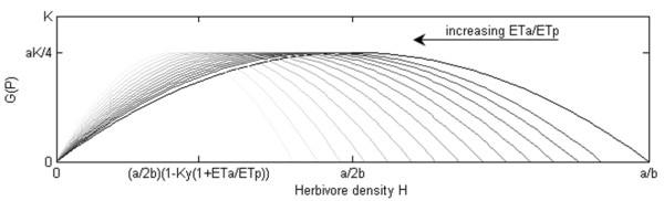
In this case, as ETa/ETp approaches unity, H approaches the theoretically predicted a⁄2b. On the other hand, when ETa/ETp decreases, the density of herbivores that can be sustained by the vegetation biomass also decreases and is largely controlled by the vegetation characteristics. As ETa/ETp decreases, the maximum density of herbivores that can be sustained by the system steadily decreases. More importantly, the system seems to move to a less stable equilibrium where small changes in the herbivore density can cause ever increasing changes in the maximum achievable growth. This characteristic makes the system more prone to abrupt shifts.
References
For ease of reading, references to other scientific work have been removed from this page. See the full report for details of all the citations